It seems fitting that I am posting this on Beltane, as it was one of Norman Lockyer’s favourite associations, which he explored, making connections between ancient sites and the sky (particularly in Cornwall) at this time of year.
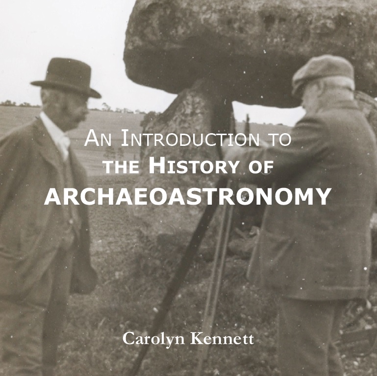
I have written this booklet as part of a series for the Society for the History of Astronomy. In it, I discuss Lockyer’s work alongside that of the many who came before and after him. Lockyer also features on the cover (many thanks to the Norman Lockyer Observatory for permission to use their image).
The booklet can be ordered through the Society for the History of Astronomy and costs £15, including postage and packaging within the UK. All proceeds go to this wonderful organisation, of which I am the current chair.
An Introduction to the History of Archaeoastronomy by Carolyn Kennett
For thousands of years, human civilisations have looked to the sky, recording the movements of the sun, stars, and planets in ancient texts. From the cuneiform tablets of Mesopotamia to the hieroglyphs of Egypt, references to celestial bodies abound.
Alongside these written records, numerous ancient structures across the globe appear to be aligned with the cardinal directions or with celestial events such as solstices and equinoxes. These structures—stone circles, burial mounds, and vast earthworks—are especially prominent throughout the United Kingdom and Ireland.
Unlike the civilisations of the ancient Near East and Mediterranean, we do not have written records to accompany many of these monuments. Their meanings have therefore been left to the investigations (and sometimes the imaginations) of those intrigued enough to study them.
Over time, scholars, archaeologists, and astronomers have examined these sites, proposing that many were designed with the movements of the heavens in mind. In doing so, they offer insights into how our ancestors may have understood and interacted with the cosmos.
This booklet traces the development of these interpretations—from their tentative beginnings to more systematic and scientific approaches. It explores the stories behind the theories, the people who proposed them, and the criticisms they faced, presenting a concise history of archaeoastronomy in Britain and Ireland as it developed into a multidisciplinary academic field.
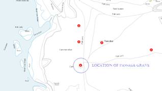
Carn-men-ellis Kerbed Cairn – Notes from the 2021 Equinox
SW 3481 2602
Latitude: 50.075005N Longitude: 5.707763W
50°04’30.0″N 5°42’28.0″W
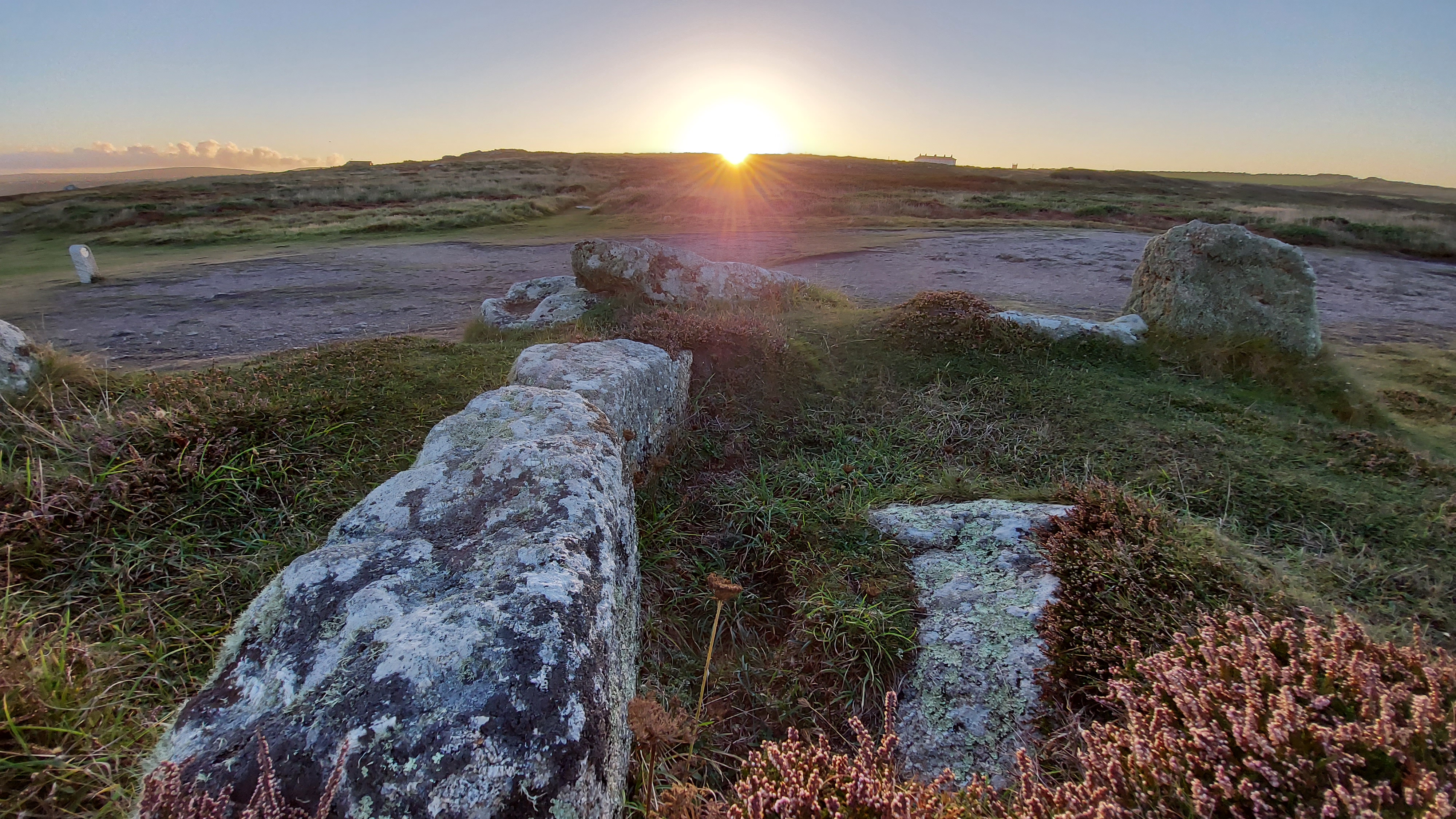
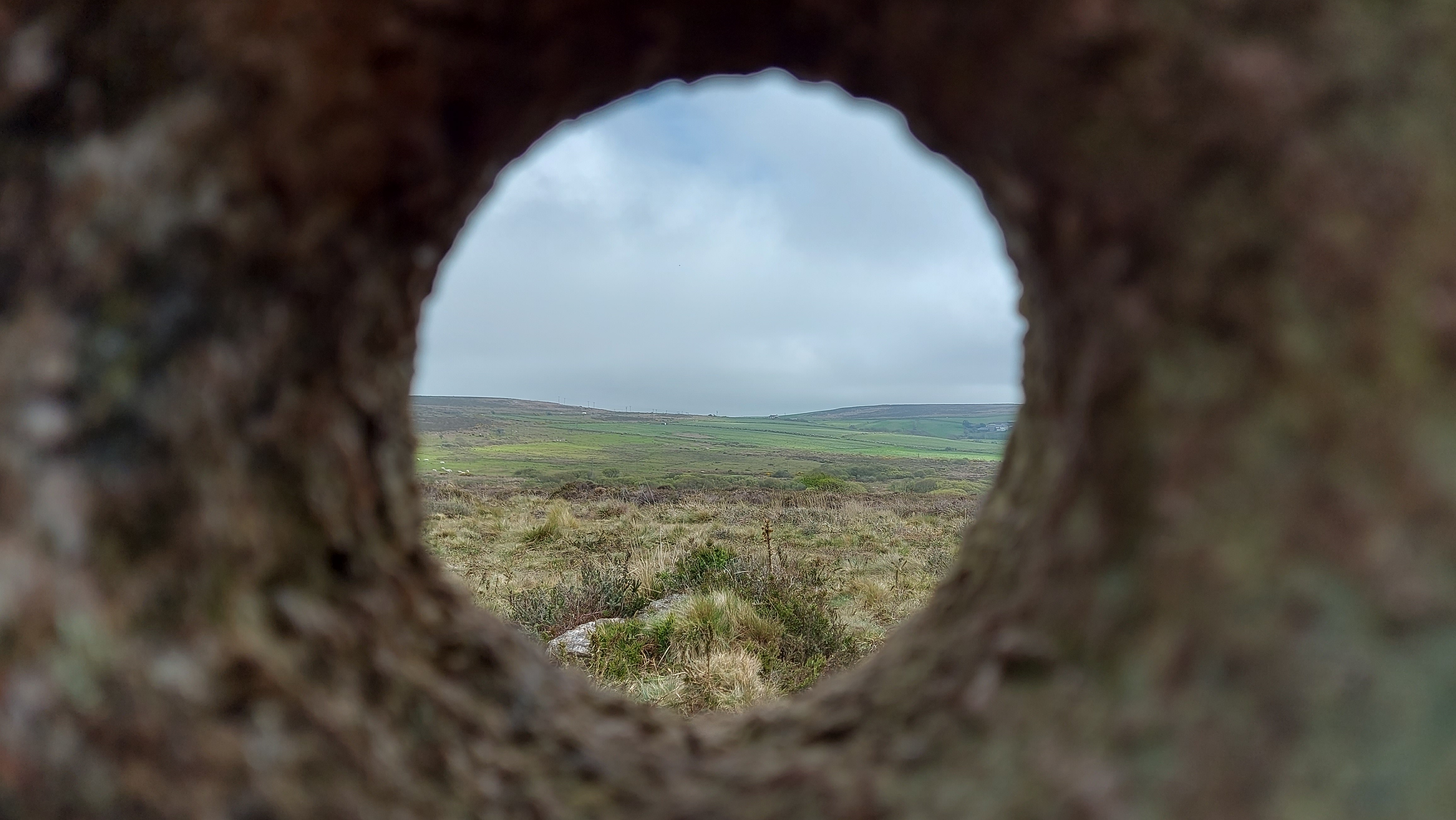
On the cliff top leading to Land’s End above Sennen are the remains of an intriguing prehistoric site known as Carn-men-ellis kerbed cairn (and cist).
This monument is dramatically positioned overlooking the western edge of Cornwall, with Land’s End visible to the south and Cape Cornwall to the north. On clear days, the distant Isles of Scilly can be seen on the horizon. The site itself sits on a gentle slope descending from east to west. In the immediate vicinity are four cairns, including one particularly impressive example that stands prominently on the north-eastern skyline. To the south, on the headland, lies the later-built promontory fort known as Mayon Cliff Castle.
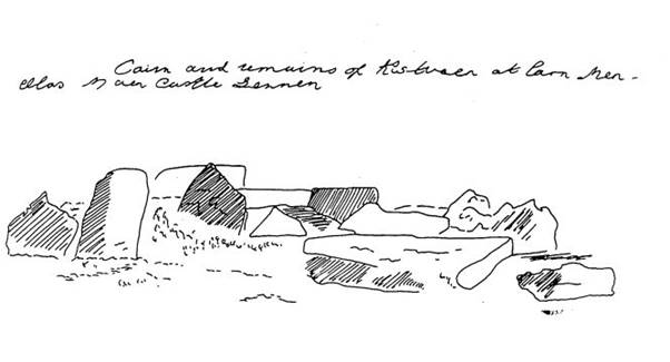
The monument has also been described as a Scillonian-style passage grave or chambered cairn, comparable to those at Tregeseal or Bosiliack. This one was excavated in 1879 by William Copeland Borlase, who recorded no finds. An early sketch of the site survives in the Morrab Library. The artist remains unknown, though it may have been commissioned by Borlase.
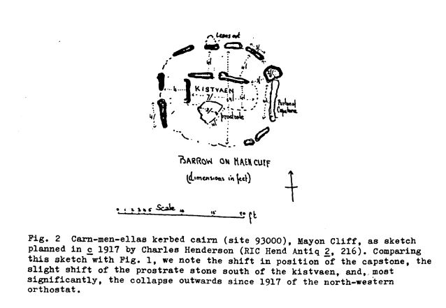
Sketched late 19th Century (Morrab Library, Misc. Pap. 44(1). Pl (17)). Possibly before Borlase excavated the site in 1879, as the dark shaded upright to the centre left was prostrate in later drawings, including a 1917 sketch by Charles Henderson below.
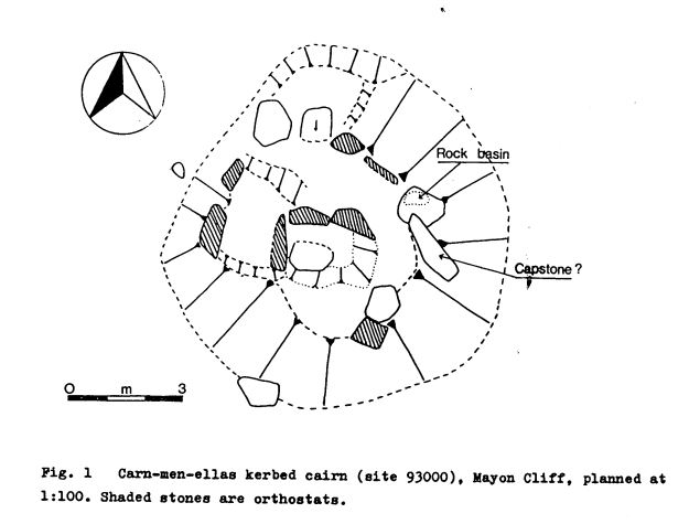
The grave was later sketched by Henderson in 1917 who labels a capstone and shows the kerb and central cist in plan form. A later assessment from the 1980s shows the moving of the capstone, an interesting stone with a rock basin and the remains of the central cist/passage area and kerb stones. This site is pretty much in the same condition as it was in that sketch.
In a 1983 survey report for the National Trust, Pete Herring suggested that the monument may have functioned as a territorial marker, a place where communities gathered for ceremonial events. A ritual or sacred centre where people gathered and sat with “their backs to the walls” of the chamber. (Barnett 1982, 49).
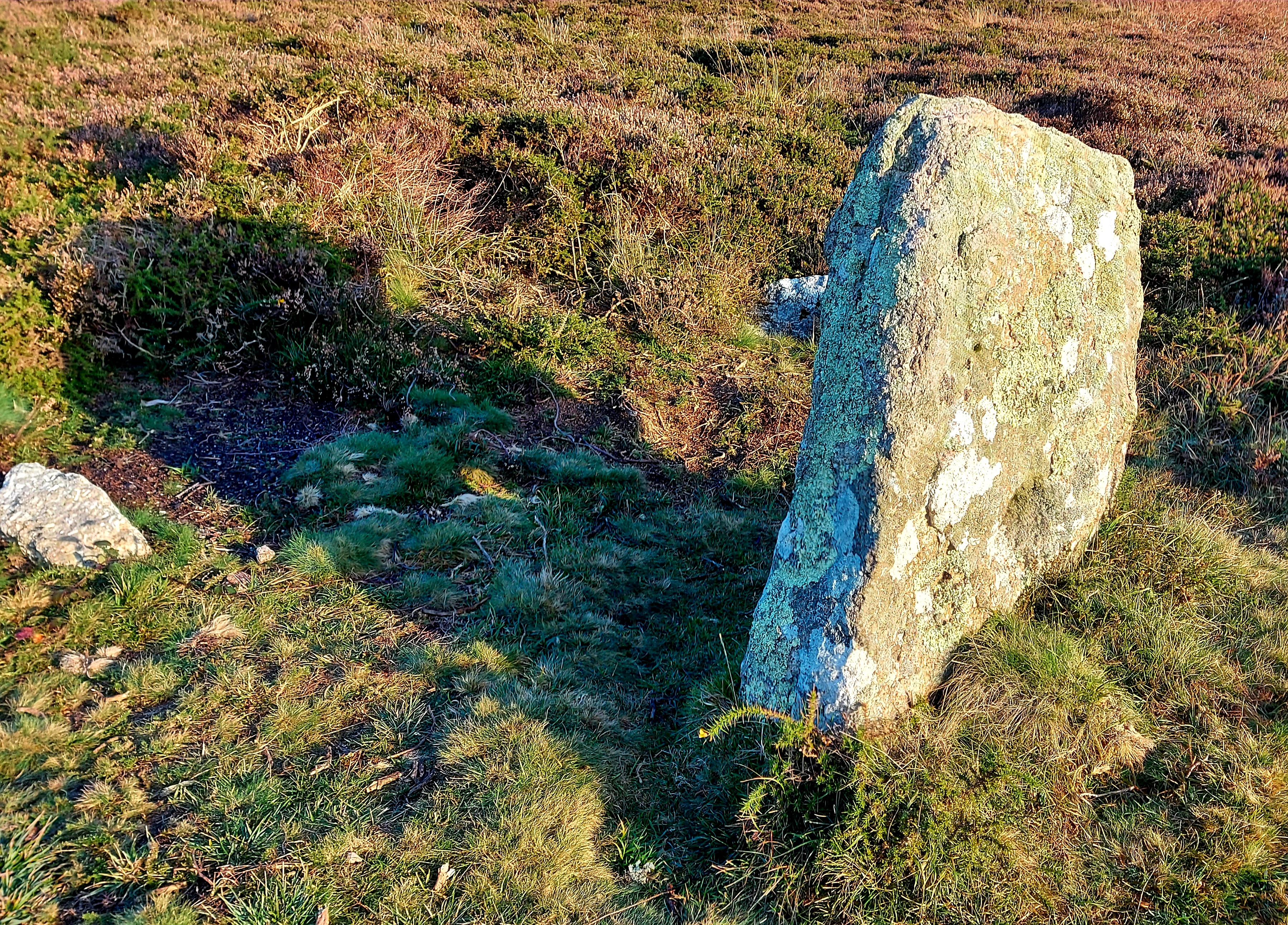
A rock basin is found on one of the stones; this would have formed by natural processes. Other rock basins have been incorporated into ancient sites. They may have signified ritual spaces as they could have been used perhaps for water collection, and maybe reflection of the face or sky, etc or adding other liquids like oil to light?. The Mȇn-an-Tol circular-shaped stone is an example of a rock basin utilised in a monument.
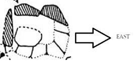
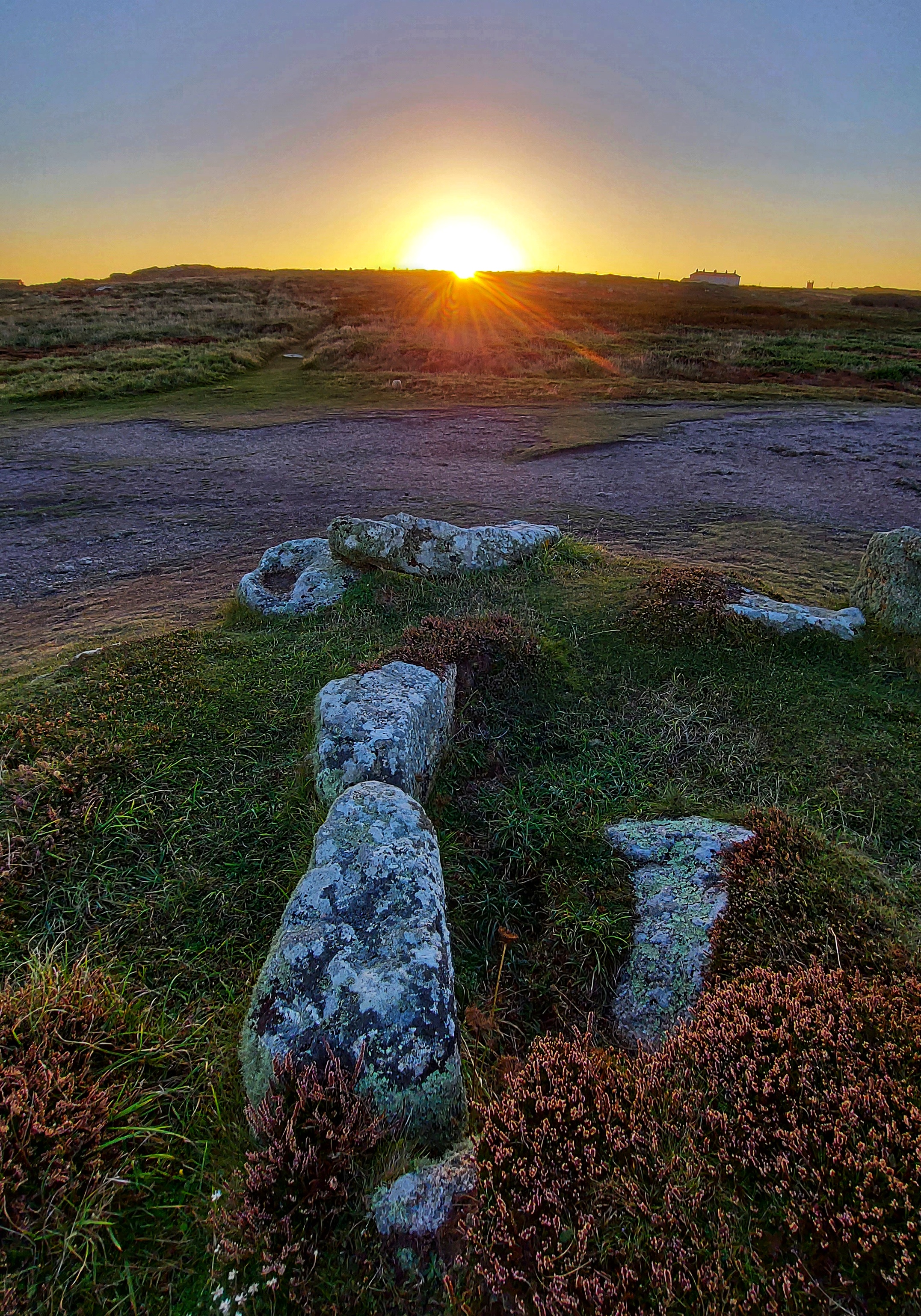
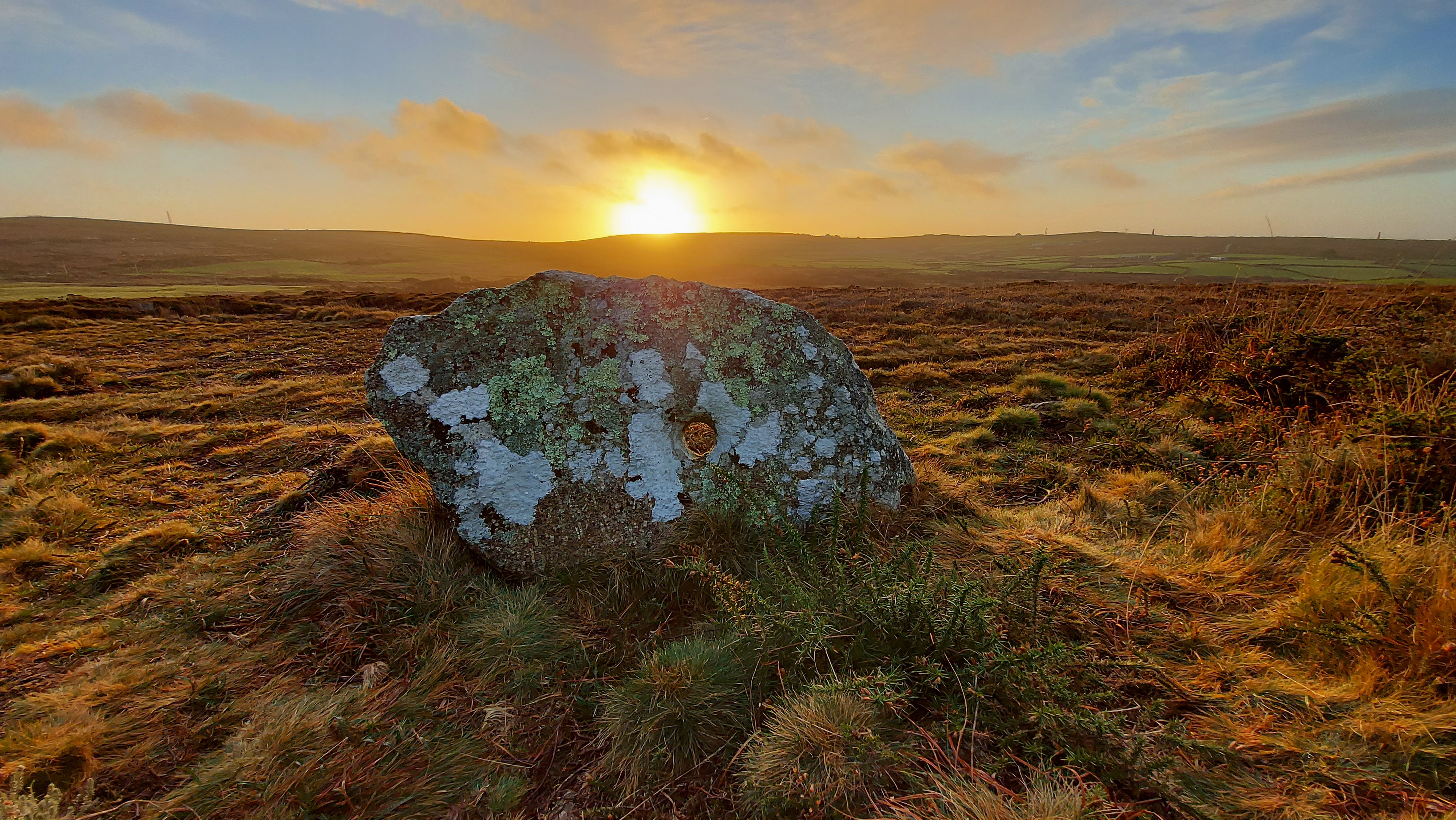
A personal visit to the site at dawn near an equinox revealed a possible alignment. The rising sun shines directly into what would have been the passage or chamber of the tomb as the back slab and chamber are oriented toward the eastern horizon. Two side stones, still in situ on the northern side of the chamber, appear to define a passage. One tapers southwards and may have restricted the light entering the chamber, like the arrangement at Treen South barrow.
This eastward orientation, which lets the sunlight enter the chamber at the equinox, is a feature shared with several other Scillonian passage tombs, as recorded by Katherine Sawyer and Paul Ashbee in their studies of sites on the Isles of Scilly. Ashbee observed that a significant number are aligned toward the eastern horizon, more so than in any other direction. Sawyer contended with 15% were facing E-W, out of 55, which could be accurately surveyed. Perhaps not an overwhelming picture of one direction proving more significant, although this was still the strongest favoured direction alongside the nearby facing ENE-WSW chambers making up 16%.
Back to this site both Henderson’s and the later CAU drawings show a site which is orientated to the eastern horizon, away from the western coastline and inland. The orientation of the chamber when it was measured was recorded at 90°.
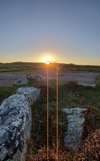
At this location, the sun rose on the morning of the 20 September 2021 at 7.29 (BST) with an azimuth 91°56’43.3. It needed to reach an altitude of 3°07’50.2 to rise above the ridge of the local hill.
The images were taken 2 days adrift from the mid-point in the solar cycle.
Adjusting these two days to the mid-point (equinox), it would rise above the ridge at an azimuth of 93°09’38.3
A difference of 1°12’55.0 or a displacement of 2 solar widths to the south (to the right in image as shown below)
Visualisation of the displacement of the sun along the horizon, between the photo date and mid-point sun (equinox) date, as seen from the rear of the chamber.
With the limited amount of information we have about the entrance area and size/possibility of an entrance passage, we can only surmise that the sun would shine directly into the chamber area for at least 2 days, either side of the mid-day sun.
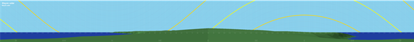
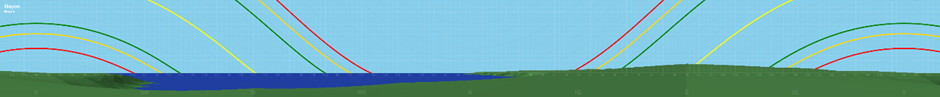
Solar rising and setting positions
Apart from the orientation of the barrow towards the eastern horizon and the mid-point rising sun. It is worth looking at its situation in the landscape with respect to the extremes of the solar cycle. Much of the horizon is distant seascapes. The Isles of Scilly make an appearance as and when conditions allow; they lie on the WSW at an orientation of 245-257°.
Only the sunrises at the solstice and the midpoint occur over land. Of these, the summer solstice sunrise is of interest as it occurs over the distant Bartinney Hill, which has an enclosure and cairns at its summit. This prominent hill has extensive views throughout the western part of Penwith. Also visible is Chapel Carn Brea. This is located just to the south west of Bartinney and can be seen in the photos adjacent to the localised ridgeline.
Horizon detailing the rising and setting positions of the sun at solstice and the mid-point.
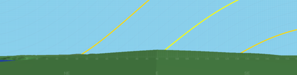
Section of Horizon showing eastern view
The yellow track is the solar position at mid-point and solstice, red and green tracks are the moon at standstill positions
Barnett, J (1982). Prehistoric Cornwall p49
Sawyer, K (2015). Isles of the Dead p59
Herring, P (1986) The National Trust Archaeological Survey, Maen Castle and Lands End p25
As the darkest of nights draws ever closer and the hours of darkness deepen. We can take comfort that the night is no empty space, the heavens open up for us and at this time of year our ancestors in the Bronze Age would have seen a great river of stars, now known as the Milky Way, arching across the sky above them. The Milky Way has long been both a boundary and a bridge. Across cultures its silvery light holds a shadow of darkness, imagined as a pathway for the dead or a dividing line between lovers. In prehistory it was likely seen as a place of wonder and story, perhaps a path trodden by gods and giants. Perhaps those who carefully set stones as a link between the circles at the Hurlers in Cornwall, or on the ground next to the towering monoliths of Dartmoor’s Piles Hill, sought to mirror the heavens upon the earth. In doing so, they brought the stories of the stars within human grasp, creating an opportunity for transcendence by reaching out to touch the world beyond. In Wales, the children of Dôn knew the Milky Way as Caer Gwydion, the castle of the trickster who strides across the firmament in pursuit of his elusive wife. And in that lost sky we may find the shadow of his companion, Bran the Blessed, raven-king of night. His presence remains in the Cornish hills at Mȇn Scryfa, a solitary menhir inscribed with memory of a royal raven, and at Caer Bran, the hillfort that bears his name. I like to think these are more than places of earth and stone, but gateways, places we may stand and look upward and perhaps trace the crow’s path along the starry river. The dark skies, once alive with ancestral stories, are no longer what they were; they have been dimmed by our lights. Where once every soul knew the sweep of stars, now only a few of us get to glimpse the Milky Way. True darkness has grown rare. Yet we are fortunate in Cornwall, where it can still be found arching across the sky. To stand at Caer Bran or Mȇn Scryfa on a clear, moonless night and watch the Milky Way blaze forth is to walk another time perhaps beside the raven.
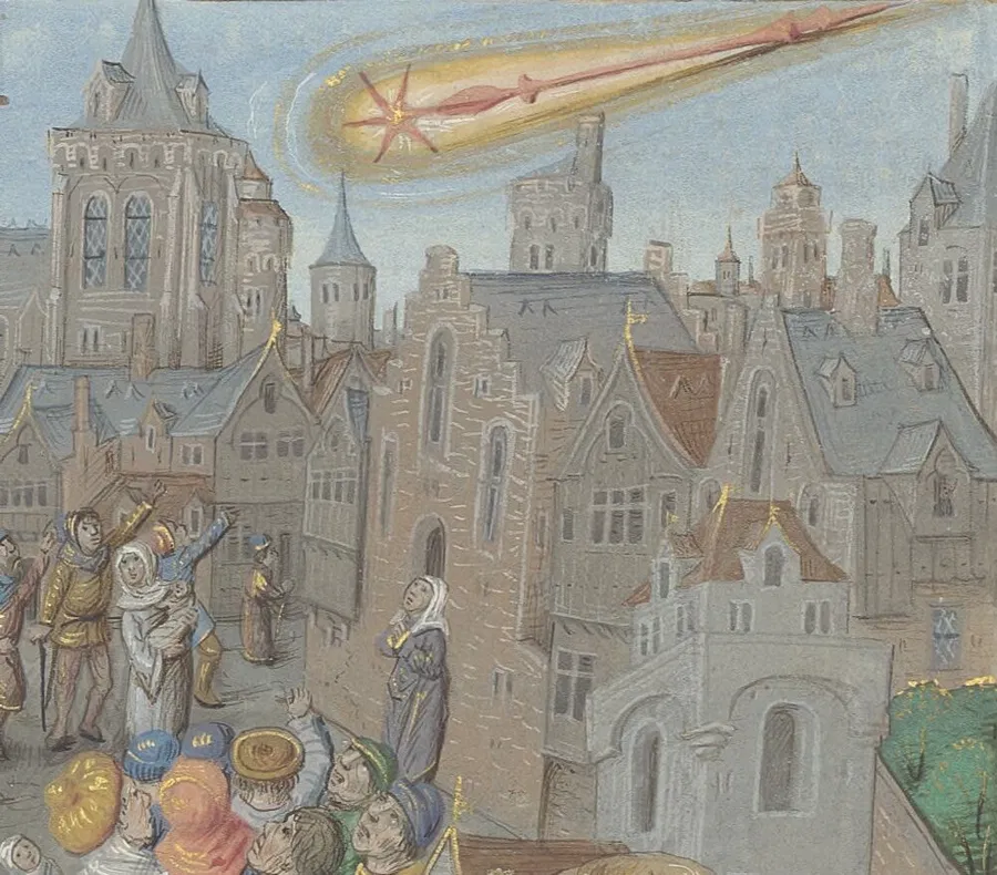
Recently, the astronomical community has been made aware of the discovery of several new comets, with one in particular poised to capture public attention: C/2025 A6 (Lemmon). This comet, discovered by the Mount Lemmon Survey in Arizona on 3 January 2025, is classified as non-periodic. Lemmon’s orbit brings it close to the Sun only once every 1,350 years, making this a truly rare event.
On 8 November 2025, the comet will reach its closest point to the Sun, known as perihelion, at a distance of just 0.53 astronomical units, or about 79 million kilometres. As comets approach the Sun, the increase in temperature causes their icy components to vaporise, resulting in the spectacular tails that are often visible from Earth.
I started reflecting on Lemmon’s previous visit, which occurred around the year 675 AD. The world at that time was vastly different: Europe was in the midst of the Early Middle Ages, the Byzantine Empire was flourishing under Constantine IV, and the Tang Dynasty was a centre of cultural and technological innovation in China. The Islamic Caliphate was advancing new ideas, and the Maya civilisation was constructing remarkable cities in Central America. It is intriguing to imagine that people living around 675 AD witnessed Lemmon’s passage, perhaps interpreting it as an omen or a sign from the heavens, as was common in many cultures.
The first comet recorded in the Anglo-Saxon Chronicles was in 678 AD, “HER ATEOWEDE COMETA AND SCAN III MON AS AELCE MORGEN SWlLCE SUNNE BEAM.” “In this year appeared the star called comet, in August, and shone for three months each morning like a sunbeam.”
Could this have been our comet Lemmon?
Determining whether C/2025 A6 (Lemmon) was a prominent feature in the night sky during its last visit is challenging. Comets with orbital periods over 1000 years can have extreme semimajor axes and eccentricity, and can fluctuate significantly in their orbital path. Also, the brightness of a comet depends on several factors, including its size, composition, and the amount of ice and dust it contains. Unfortunately, historical records from the 7th century are limited, so we cannot say with certainty how striking an appearance may have been. However, given its close approach to the Sun, it is plausible that Lemmon was a noticeable and memorable sight.
Whatever this comet was, it had a lasting effect on Saint Wilfrid of York, who was a powerful Northumbrian bishop in the seventh century who ruled a large number of monasteries. In the year 678, when the comet appeared, it was seen as a bad omen, and Bishop Wilfrid was driven from his bishopric after quarrelling with King Ecgfrith of Northumbria.
Happy comet hunting all
Also appears as Oct enews Chair Chat – Society for the History of Astronomy
Bibliothèque de l’Arsenal, Ms-5206 réserve, fol. 152r
Back in May I was kindly invited to speak about the wonderful Cornish ancient sites on Bodmin Moor and the research I have been doing into the relationship they have with the sky. Here’s a link to the talk,
Written after the April 2023 archaeological investigation of the stones
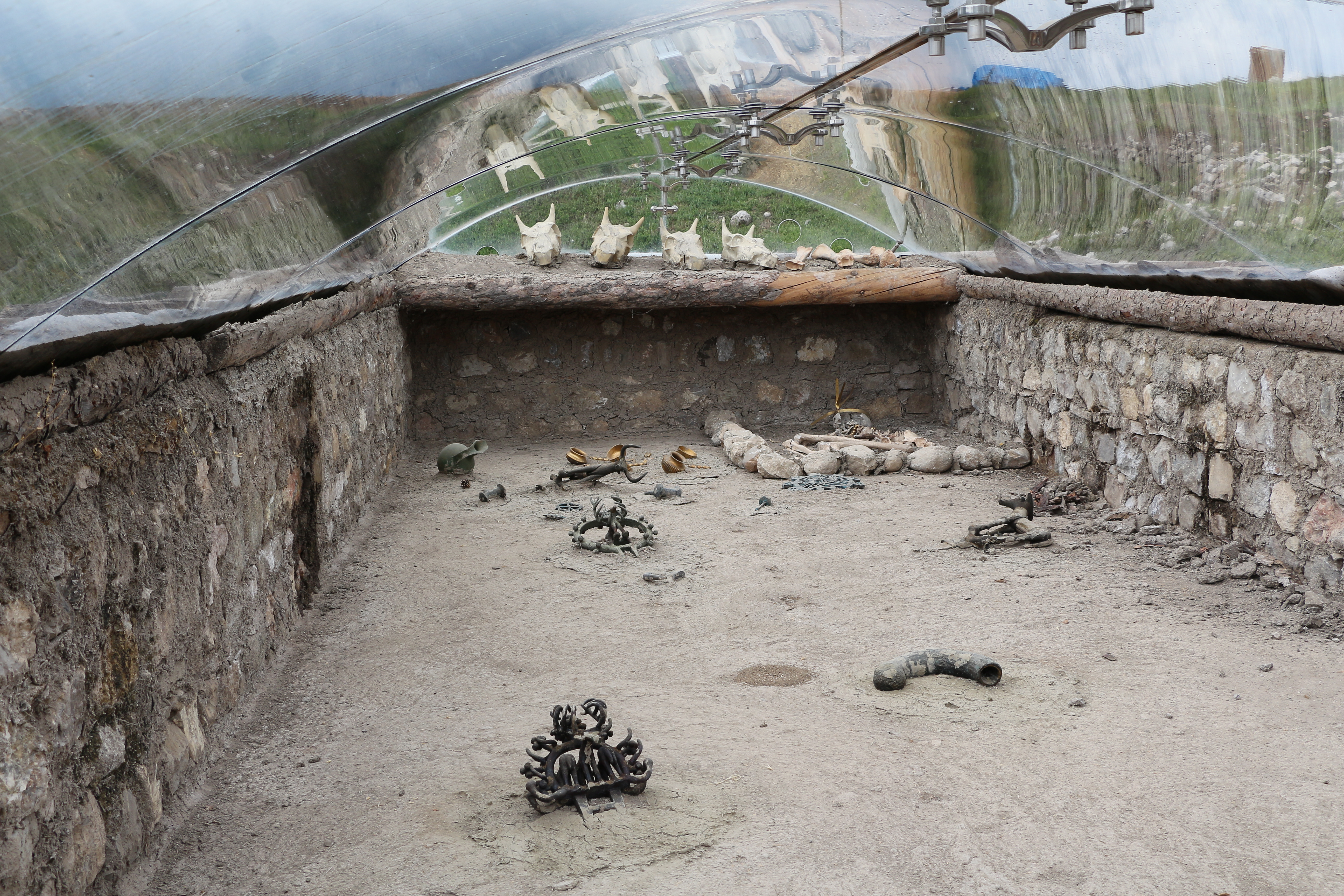
Adjoining the ritual landscape of Tregeseal near St Just, Cornwall lay a curious collection of stones known as the Kenidjack Holed Stones, which are named after the common land on which they are sited (Latitude 50.1360°, Longitude -5.6537°). The site consists of four large granite slabs each perforated with a circular hole currently positioned in a row with an ENE-WSW orientation of 67°, with a further fifth smaller holed stone a few meters to the NW of the main row. The stones are distinctive due to being a collective group with holes, and while there are other examples of holed stones in west Cornwall (including a number near the Merry Maidens stone circle), it is unusual to find a group of them together. It is considered that they are most likely a collected monument which relates to the local Bronze Age barrows, stone circles and other monuments within the immediate location. They were drawn in 1842 by John Buller laying prone on the floor.[1] All the stones have likely fallen and been re-erected a number of times. In 2020 one of the stones became loose and fell over, the hole in which it had sat was very shallow and although it was propped back up it needed to be reset in the ground in a more robust manner. By 2023 a second stone was also becoming loose and this led to the opportunity to examine if there was any evidence of their original positions in the ground immediately surrounding them or if these had been lost. The archaeological investigation was led by Peter Dudley of the Cornwall Archaeological Unit with support from Laura Ratcliffe-Warren and a team of volunteers from the Penwith Landscape Partnership. Historic England grant-funded the work as part of the monument management programme of conservation works.
The monument consists of the four larger stones in the row and a further outlier stone to the main row. The stones in the row have been called A-D for the purposes of this investigation (with E being the outlier). Three stones in the row are upright while the fourth lays prone and broken with only half of its hole still visible (as it was drawn in Buller’s early sketch). The smallest holed stone is an outlier to the NW of the row and has likely been moved from its original position and re-erected with a viewpoint of the outcrop of the top of Carn Kenidjack in mind. It was photographed in 2010 broken in two and has been reset in its current location.[2]
Image: Stone Row with each stone labelled from A – D
Credit: Carolyn Kennett
Stone A and Stone C were subject to the archaeological investigation conducted over two days in late April 2023. Two separate 1.6 x 1.2m trenches were opened up in the immediate area around stones A and C before both were replaced in the same position as before the conservation works. In an effort to make stone C more secure it was reset with its long edge into the ground and short square edge at the top. The chosen side being matched to Charles Henderson’s 1922 drawing of the stones.[3]
Image: Stone C following the 2023 conservation works
Credit: Carolyn Kennett
There was no evidence of any original setting or ground disturbance relating to Stone C. In Charles Henderson’s drawing, he has this stone positioned closer to Stone D and this could be the reason that no ground disturbance was found.
Beneath the location of Stone A the team uncovered the edge of a possible large pit or hollow, with a fine greasy layer at its base. From its texture, the layer was possibly organic-rich in its composition. Within this was a discarded rough flake of flint (also burnt), knapped off from the outer edge of a flint nodule. It is difficult to date the pit/hollow, especially considering the later changes to the monument. It could potentially date from the erection of the monument and perhaps indicate that there was a fire in the vicinity of the stone, however, without full excavation, a fuller understanding is difficult to establish. Care was taken not to change the orientation of the stones although Stone A was buried approximately 20cm deeper than it had previously been to ensure its long-term stability.
It was concluded that the monument had undergone disturbance in both orientation and original positioning of the stones. The earliest description of the stones has them positioned in a line and there is nothing to suggest they would have stood in any other way. The 2023 archaeological investigation found little indication of their original position. Therefore the following is a suggestion of what may have proved interesting about the holes and related skyscapes at the site during the Bronze Age, rather than a definitive conclusion about the orientation of the stones, holes and related skyscapes. This examination tentatively discusses the possible role of the holes in their relationship to the cosmos while taking into account the challenges of orientation.
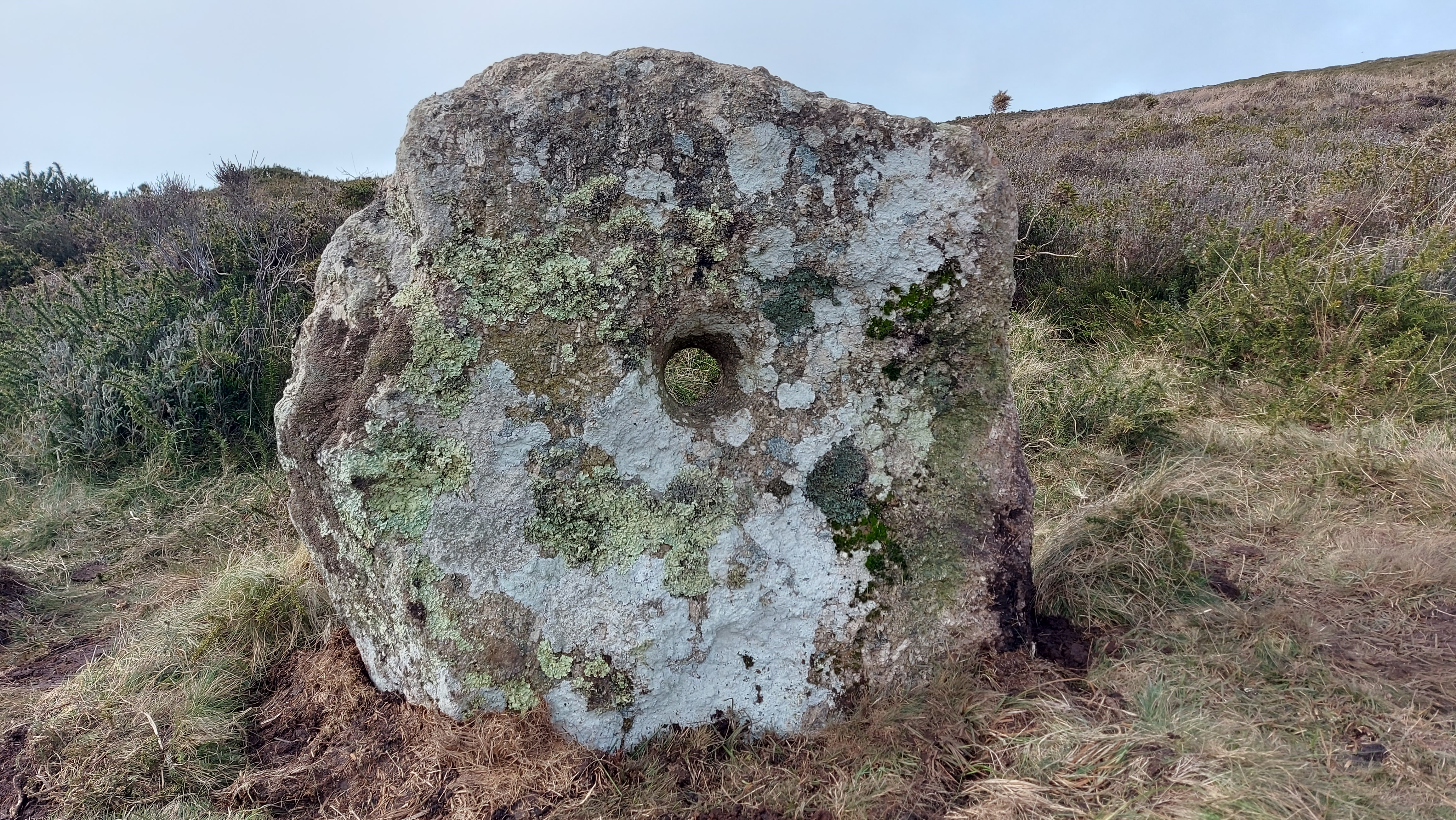
Looking directly through the holes
Image: Sunrise through stone D, 17th December 2021
Credit: Carolyn Kennett
The stones are located on the side of an eastern slope leading up to Carn Kenidjack and keeping this feature in sight at the monument may have been important in the choice of location of the row. Each hole is positioned low on the stone and the rise in slope makes it impossible to observe the sky when looking towards Carn Kenidjack through the holes, and you can’t see the sky in this direction. Looking through the holes in the opposite direction gives a slightly different view of the southeast horizon, as the stones are each positioned at a different angle in the row. Due to the aspect of the site and the rise in slope, it makes more sense that any observations of the sky made through the holed stones would be limited to this general direction. The current orientation gives sightlines through the holes with azimuths between 105° and 135°. This relates to rising objects of the celestial sphere and it is possible to see the sun, moon and a number of stars in this direction as they move through their celestial cycles. The stones could have been orientated to watch for seasonally important sun and moon rises or helical-rising stars maybe marking chosen calendrical events.
Image: Horizon positions which are observable through the holes (pre-archaeological investigation)
Credit: Carolyn Kennett
Image: Profile of horizon (horizon scale exaggerated x7)
Credit: Graphics by HeyWhatsThat
After the investigation, Stone D’s orientation to the furthest southeast part of the horizon remains unchanged. Stone C was orientated towards the ESE, resetting the stone hasn’t changed this orientation by much and it still faces the lower ground between the two ridges on the horizon.
Image: Horizon view through Stone C following the 2023 conservation works
Credit: Carolyn Kennett
Stone A is orientated centrally of the three. This orientation changed little after the stone was reset and still was centred on the distant southeast ridge. When looking directly through the holes at the horizon there is a crossover with Stone C and D’s views.
Image: Horizon view through Stone A following the 2023 conservation works
Credit: Carolyn Kennett
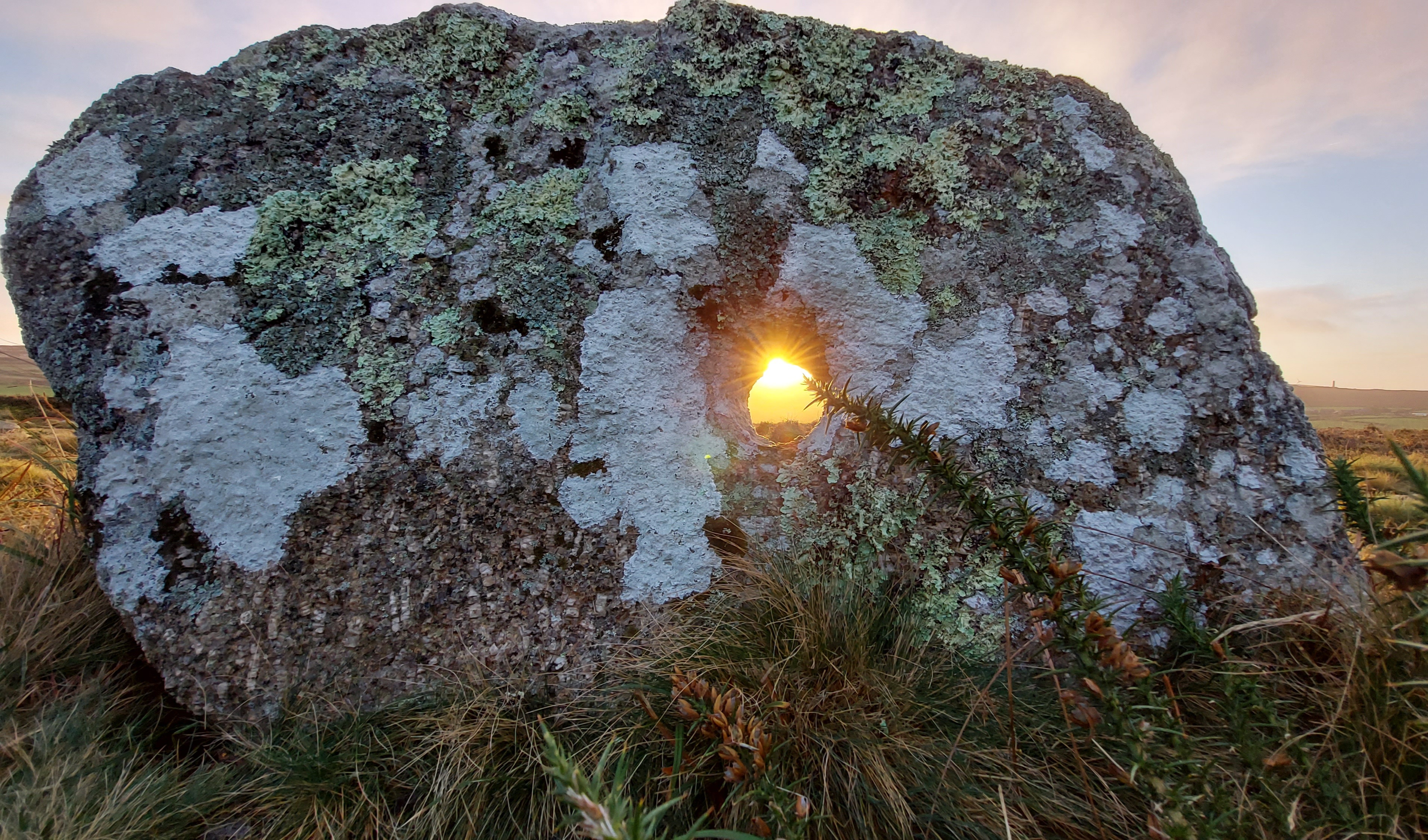
The sun and the holes
The sun changes its rising position throughout the year, rising directly in the east at the equinox and furthest to the northeast for the summer solstice while rising at its furthest point to the southeast at the winter solstice. If the stones were orientated in the way they are today there would have been times when the sun would rise and shine directly through the holes. Could the holes be used to observe the rising sun through them?
Image: Sunrise through stone A, 1st December 2019
Credit: Carolyn Kennett
The location of the holes low to the ground gives an uncomfortable observing position and looking directly at a rising sun is fraught with danger as the sun can cause serious damage to the eyes. There is an alternative way in which the sun, hole and stone could work in unity. Instead of looking directly through the hole, an observer waits until after the immediate sunrise for a shadow to form behind the stone. The shadow only takes minutes to form after sunrise and if the stone is orientated to a corresponding part of the horizon where the sun rises a beam of light shines through the hole onto the ground.
Image: Sunrise through stone A, 6th December 2020
Credit: Carolyn Kennett
The rising sun will form a circular sun beam onto the stone’s shadow. The connectivity between the sun, stone and shadow may have been of interest to the people who created the holes in the stones. As a phenomenological effect, it could have been perceived as a mastering of the sun itself (a possible deity) by casting it down, bringing it to earth while shrinking it and harnessing its power and warmth at ground level. I can speak from experience when I say that the concentration of sunlight shining through the hole is a great way to warm your hands on a cold morning! Alternatively, It could have been seen as a demonstration of light overcoming darkness, with the sunbeam forming centrally in the dark shadow behind the stone.
Image: Sunbeam shining through the hole captured onto a piece of card
Credit: Carolyn Kennett
The sunbeam is an ephemeral, time-sensitive feature. It would only be visible within the shadow for a number of consecutive days, for a few minutes at a time. All the holes are of similar diameter and in theory this would allow the holed stones to be used as a rough calendrical device from the number of days the sun would shine through the hole. If the holed stones were standing similarly to their current positions then each hole aligns with a different set of sunrises which partly overlaps because of the view of the horizon through the holes.
The angular diameter of the sun, corresponding hole and distance to the eastern horizon means that the sun would shine directly through the holes for approximately 20 consecutive days (there is some discrepancy in this as the daily displacement of the sun is not uniform during the solar year). In their current positions Stone C correlates to the sun rising from early November to late November, stone A corresponds to dates from late November to mid-December and Stone D relates from early to late December including the rising sun at the winter solstice. There is a large crossover in dates between Stone D and Stone A and the people who positioned the stones may have purposely made the sunbeam shine through multiple holes with the overlapping highlighting more significant dates.
Stone B may have filled in the gap in sun beams and acted as a midpoint between Stones C and A. Stone D’s orientation includes part of the horizon which is too far south to see the sunrise during the annual cycle. In its current position, the rising winter solstice sun would be a central feature to the hole. It is unlikely we will ever know the orientation of stones but if they are any way similar to their position today they could have acted as a calendar and functioned (with the other prone stone) as a countdown signal perhaps to the winter solstice,.
Image: Sunrise through Stone C, 1st December 2019, at this angle the sun no longer shines all the way through the hole
Credit: Carolyn Kennett
The first linked sunrise would occur around the cross-quarter period known as Samhain and a time to harvest, while the final holed stone is centred around the time of winter solstice when the sun reaches its most southerly position. The holes would unlikely have been used as an accurate dating tool, instead, it could have been a method of honouring the importance of the sun at this time of year. Capturing and ground casting the sun during the darkening of the seasons could have been seen as significant. The other monuments in the immediate locale have connections to the winter solstice festival. Tregeseal passage grave in the valley below is orientated to the winter solstice sunrise and contained a cross-based urn linked to solar symbolism.[4] Furthermore, the Tregeseal stone circles are focused on a sea gap which incorporates a liminal view of the Isles of Scilly 26 miles off the coast and the winter solstice sun sets in that direction when observed from the circles. Locally the Neolithic Chûn Quoit has an alignment to Carn Kenidjack suggesting this was a longstanding important location to mark the winter solstice.[5]
Observation of light beams in shadows allows people to observe the sun indirectly, while not hurting the eyes as would occur with direct observation, much the same way pinhole projection is used today within astronomy. This method may have been used at another holed stone in Cornwall, through the hole in the capstone at Trethevy Quoit. When the sun reaches its zenith during the summer months it rises high enough in the sky to shine directly through the hole casting a sun beam onto the ground below. This occurs on the summer solstice at noon (UT).
In theory, the full moon could work in a similar way to the sun, shining moonlight through the holes onto the shadow behind the stones and could relate to different full moons as it moves through its phase cycle. The full moon is working in opposite to the sun, being reflected sunlight, so the time of year it would be shining through the holes at full would be in the summer months. In many ways, the full moon in the summer months is less significant than that of the winter full moon. The daylight hours in the summer are much longer and the full moon rises and sets low in the southeast making less of a visual spectacle than in the winter months. It is not rising high like in the winter months, where the full moon played a role in bringing more light to dark nights. At the holed stones latitude of 50.136°, there is little astronomical darkness around the summer solstice and the moonlight would be diffuse and dim and unlikely to cast a moon shadow or light through the hole. It seems more likely that the rising sun would be visually impactful and significant.
Helical-rising stars and seasonal timing
Helical-rising stars have been used in many societies to set dates and festivals. This is a significant moment when a bright star can be seen rising in the morning for the first time before dawn light drowns it out. The motion of the Earth means that stars are seasonal and they rise approximately 4 minutes earlier each day. At times of the year, certain stars are not visible and their return to the night skies can herald the start of a season. The return of Sirius to the skies was used in such a manner by Ancient Egyptians, while the star group the Pleiades were used in this way in Ancient Greece.
The stones could have been positioned to watch for certain helical bright stars rising. This would involve the observer laying prone observing the night horizon directly through the hole. The horizon in this direction is fairly uniform, it has an elevation of 1.2-2.2° above 0. As the stars would be observed low to the horizon a person would be looking through a thicker layer of atmosphere and the light travelling from the stars would be scattered making them hard to see. Therefore only the brightest of stars would be observable at these low elevations. The holes could in effect help by limiting the view. If you hold up your hands in front of you and form a circle in which to look through you will note that you are narrowing your perspective to a more focused view, it’s an optical illusion but could aid with sharpening the view. Looking through the holed stones creates the same effect as you narrow your worldview. The only stars visible would have an apparent magnitude 1.5 and brighter. Star’s positions change due to precession. For instance, the bright star Sirius would rise at this latitude with an azimuth of 125° in 1500BC and 131° in 2500BC, as there is no accurate date from the monument this means that stellar objects over a wide range of declinations have to be considered.
The holes correspond to a horizon range which covers the rising positions of celestial objects with declinations between approx. -10° and -35°. Following is a table with bright stars observable at this latitude. The yellow highlighted ones have orientations which correspond and could have been seen to rise within one of the holed stones during the early Bronze Age period of 2000BC.
Star
Apparent
Declination
Declination
Declination
Declination
Declination
Right ascension
Name
Mag.
3000BC
2500BC
2000BC
1600BC
J2000
J2000
Sirius
-1.46
-22°21’15”
-20°42’47”
-19°16’55”
-18°17’55”
-15°25’28
-18°17’55”
Arcturus
-0.04
48°33’57”
45°44’31”
42°47’42”
40°22’44”
21°24’54”
14hr21m0s
Vega
0.03
43°59’58”
42°36’06”
41°23’05”
40°32’46”
38°26’25”
18hr36m20s
Capella
0.08
26°10’08”
28°53’10
31°33’38”
33°38’33”
46°26’38”
5hr15m40s
Rigel
0.12
–25°37’54”
-23°04’02”
-20°37’32”
-18°46’39”
-8°12’04”
5hr14m31s
Procyon
0.38
2°58’48”
4°31’55”
5°49’32”
6°39’36”
6°15’46”
7hr42m56s
Betelgeuse
0.5
-7°27’02”
-4°57’60”
-2°38’03”
-0°53’50
7°23’45”
5hr55m1s
Altair
0.77
9°58’52”
8°34’10”
7°25’26”
6°42’35”
8°28’33”
19hr48m0s
Aldebaran
0.85
-4°46’48”
-2°02’23”
0°39’18”
2°45’17”
16°42’25”
4hr35m35s
Antares
0.96
-4°08’35”
-6°55’16”
-9°40’28”
-11°50’08”
-26°24’23”
16h29m26s
Spica
0.98
14°42’23”
12°35’39”
10°16’60”
8°18’55”
-11°07’23”
13hr25m24s
Pollux
1.14
22°51’10”
24°49’07”
26°31’51”
27°41’40”
28°11’30
7hr48m56s
Fomalhaut
1.16
-43°58’06”
-44°11’06”
-43°57’28”
-43°27’45”
-29°25’25”
22hr55m50s
Deneb
1.25
36°30’34”
36°28’47”
36°39’38”
36°57’23”
45°16’43”
20h41m25s
Regulus
1.35
23°36’39”
23°55’41”
23°52’48”
23°34’45”
11°54’50”
10hr09m41s
Adhara
1.5
-33°38’01”
-32°09’34”
-30°53’29”
-30°01’54”
-28°58’24”
6h58m36s
Castor
1.57
24°51’48”
27°00’26”
28°54’51”
30°14’31”
32°04’45”
7hr35m40s
Pleiades
1.6
0°05’22”
2°49’59”
5°36’07”
7°48’42”
24°22’03”
3hr45m49s
Only three stars are considered to be close matches to the holes, these are Sirius, Rigel and Adhara and due to the little correlation between the brightest stars in the sky and the position of the holes, it seems very doubtful that they were used to observe helical rising stars.
To conclude, if the holed stones were used as observational tools the most probable method would be linked to viewing the sun. It seems most likely that the best method for doing this was watching for the beams of light to be cast through the holes made by the rising sun. It’s dramatic watching the beam of light illuminate the shadow cast by the stone and I really recommend getting up on a winter’s morning to witness this if you get the chance.
Image: Sunrise 17th December 2020
Credit: Carolyn Kennett
[1] Buller, John (1842) A Statistical Account of the Parish of St Just in Penwith in the County of Cornwall. Dyllansow Truran p. 100
[3] Charles Henderson’s 1922 sketch of the stones (taken from the 2011 report on the conservation works to the lone stone – Preston-Jones, A, 2011. Kenidjack holed stone, St Just, Cornwall – repair and restoration. Truro: Cornwall Archaeological Unit, 2011R119)
[4] Kennett, Carolyn (2021) Burying the Sun, Crossed Based Urns and Solar Symbolism. Astronomy Yearbook, White Owl Press. p 152.
[5] Kennett, Carolyn (2021) Tregeseal Circles and the Solstice Sun. Meyn Mamvro Vol 2. No 3. pp.8-10.
Royal Tomb at Alaca Höyük where a hoard of meteorite objects was discovered. – CC credited to Bernard Gagnon
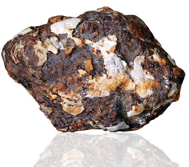
Metals played a crucial role in the advancement of human civilization that ancient eras, the Bronze and Iron Ages, have been named after them. But pinpointing an actual date on which humans first worked metal into objects is hard to do. In Europe, this could have been as early as 7000 BCE. Brightly coloured copper and gold were utilised first, while extraction of tin and iron came later. A move from the Stone to the Bronze Age was made possible in about 2500 BCE due to the discovery that smelting copper with tin created the durable alloy Bronze. While the move to the Iron Age came much later, about 1200 BCE. Iron is widespread in the geological landscape but extraction and smelting of this metal into a usable form proved incredibly complex. Therefore perplexing is the existence of Iron objects which predate the Iron Age, some of these objects are at least 9000 years old and are from as early as the first worked metals. Another source of iron is non-terrestrial. It arrives on Earth from outer space in the form of meteorites and it has been suggested that the utilisation of meteorites found on the surface could explain the presence of iron objects which predate the Iron Age. This would make meteorite objects some of the earliest encounters that humans had with metal.
It is not difficult to imagine that people would have admired and craved something unique, much in the way we do today. This is an easy concept to understand in a modern context, as in today’s world ‘things’ matter; there is no denying we currently live in a material world. Objects enrich our lives; we use them as embellishments and allow them to express our identities and our hopes and fears. This is not a modern phenomenon, walking around any museum we can see how longstanding the relationship to material objects is. In a world without modern materials and predating the times when the method to smelt iron was common knowledge, the properties of iron would have been special and even without knowledge of its origin would have seemed otherworldly. Manipulation of this material most likely occurred with cold hammering as open fires would not have the heat for smelting the metal. It would have shown the object to be shiny, durable, hard but malleable and made of something which could become useful such as a tool, sharp dagger, talisman or simple beads. There is no suggestion that in all cases people saw the meteorite fall and collected the deposit but in some examples, there is a real possibility this was the case.
The examples of worked meteorite objects below will demonstrate how rare and highly prized this material was. This is not an exhaustive list as the exact number of prehistoric worked meteorite items changes continuously, not only due to new discoveries but re-examination of existing collections with better identification techniques and more precise dating of prehistoric objects. Historically the easiest and most accurate way to Identify meteoric iron has been by an inspection of its isotopes looking for raised nickel content within the object, in comparison to terrestrial iron which has no or little trace of nickel. Early methods were invasive and involved some destruction of the object to provide a sample. Further complicating identification is that different nickel readings can occur depending on the location of the object tested, so one sample from the same object may result in a different reading than another.
Modern testing techniques aim for greater accuracy in identification and now use a ratio of three elements cobalt, iron and nickel, while non-invasive techniques such as X-Ray Spectroscopy increasingly play a part as they do not involve damaging these often fragile objects. What the use of X-Ray Spectroscopy has revealed is that particularly corroded specimens may have little nickel content at all. These objects could have been mistaken as being terrestrial but iron objects with no nickel content may still have been delivered from space. Albert Jambon, from the National Center for Scientific Research (CNRS) in France has imaged many of these fragile items with his X-Ray Spectroscope and has identified a number of new specimens and explains that “Some archaeologists were sceptical, as they thought that the amount of nickel found in Bronze Age iron tools was too low to consider them of meteoritic origin, But I’m a trained cosmochemist, so I knew the problem was just corrosion. And I was able to show that nickel was leached away during corrosion.” Modern techniques are increasing the number of known objects which are meteoritic in origin.
Meteorite fragments from inside the remains of a hut dating back more than 9,000 years in Bolków by the lake Świdwie in Western Pomerania. Credit: Archaeologists from the Institute of Archaeology and Ethnology (IAE) PAS
Only sixteen known iron objects predate 3000 BCE and these are outlined in the table below. The earliest worked meteorite objects, three beads, were discovered recently in 2014 at Lake Świdwie Poland. This exciting discovery was mentioned in the 2020 Yearbook in Astronomy. Dating from 7000 BCE this is not only the earliest example of meteorite-worked iron but one of the earliest worked metal objects in the world. Due to the location of its discovery, the significance cannot be overstated. All the other objects from this period come from the cradle of civilisation and northern Poland sits well outside this region. Prior to this the nine blackened beads found in a pre-dynastic cemetery near el-Gerzeh, Egypt were the oldest known worked iron meteorite objects. The beads were scanned and revealed the distinctive Widmanstätten structure found in iron meteorites. During this investigation of the beads Professor Thilo Rehren of the Petrie Museum, (University College London) discovered a little about the technique used to create the objects saying “The shape of the beads was obtained by smiting and rolling, most likely involving multiple cycles of hammering, and not by the traditional stone-working techniques such as carving or drilling which were used for the other beads found in the same tomb.” Furthermore, he felt that the Egyptians had an advanced understanding of the material they were using, suggesting that they had worked with the material before. The final object in the table below is a bit of an anomaly itself. It was identified as terrestrial smelted iron, a four-sided tool which was discovered in a tomb in Samarra in Mesopotamia. One suggestion is that the iron used in this object was obtained as a by-product from the extraction of another metal, although that does not explain how the society overcame the difficulties of achieving the high temperatures needed for the smelting process. It is a real possibility that retesting using Jambon’s Spectroscopy technique would identify it as being meteoritic in origin.
Object
Date
Location of find
Other observations
Beads x3
7000BCE
Lake Świdwie, Poland
Worked – found in Shamans hut
Balls x3
4600-4100BCE
Tepe Sialk, Iran
Polished but unworked – hard and heavy – found in Palace
Beads x9
3200BCE
El-Gerzeh, Egypt
Widmanstätten structure – Grave goods. 9% Ni
Four-sided Tool
5000BCE
Samarra Mesopotamia
First non-meteorite smelted object? Grave goods
The Gerzeh bead is the earliest discovered use of iron by the ancient Egyptians. Credit: Manchester Museum
During the following millennium, the number of iron objects increased, although they are still rare compared to other metallic objects made from copper or gold. Iron was still highly prized and treated as a precious metal. All the discoveries are objects of significance and include jewellery, decorative items and ceremonial weapons and have been discovered in sealed hoards, near temples or deliberately buried in rich graves. These objects were not intended for everyday use and were luxury goods, much sought after by the populous. There are nine confirmed meteorite objects from this period, including the hoard from Alaca Höyük.
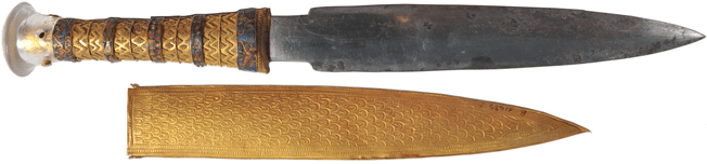
One unanalysed example from this period includes an iron sword found in a Royal Tomb in Dorak, Egypt dated to 2400BCE it is a beautiful early example of a ceremonial weapon. It has an obsidian holt carved into two leopards, inlaid with gold and amber spots. Unfortunately, this example was excavated surreptitiously and is now lost, our knowledge of this object comes from a cartouche of the Fifth Dynasty of Egyptian pharaoh Sahure. This example shows the problem in making a comprehensive list and there are at least another ten examples which have not been confirmed as being meteoritic in origin and therefore do not make the list below.
Object
Date
Location of find
other observations
Fragment
3100BCE
Urak, Mesopotamia
Found in temple
Disc
2500BCE
Ur, Mesopotamia
10.9% Ni found in tomb
Pendant
2400BCE
Umm el-Marra, Syria
Found in Tomb
Pins x 2
2400BCE
Anatolia, Turkey
Found in tomb
Plaque
2400BCE
Alaca Höyük Turkey
Found in tomb
Dagger
2400BCE
Alaca Höyük Turkey
First discounted as terrestrial iron but retested and identified at meteoric in origin
Mace Head
2400BCE
Alaca Höyük Turkey
Found in tomb
Amulet
2100BCE
Deir el Bihari Egypt
Tomb of Princess Aa Shait Dynasty XI
Dagger from Alaca Höyük TurkeyCredit: Noumenon Wiki Commons
During the late Bronze Age (2000-1200BCE) there are a greater number of confirmed meteorite examples with twenty-three being identified to date, although over fifty objects remain to be analysed. What is interesting is that no smelted objects from this period have been identified, with the Iron Age about to burgeon you would almost expect some isolated examples of terrestrial smelted iron objects so the lack of them is curious in itself. Once more the meteorite examples are geographically scattered. Overwhelmingly nineteen of the objects come from Tutankhamun’s tomb in Egypt, surprisingly these objects did not come from a singular iron meteorite drop but from three different meteorites. This suggests that the meteorites were being actively looked for by the populous to be made into grave goods. Within the list are objects which are more utilitarian such as chisels found in Tutankhamen’s tomb, these were still highly prized grave goods and do not demonstrate a regular usage of the material.
Object
Date
Location of find
other observations
Fragment
1600BCE
Crete
20lb piece unworked found in Minoan Palace
Axe
1400BCE
Ugarit Syria
Decorated with gold – ceremonial
Axes x 2
1400BCE
China
Shang Dynasty
Dagger
1350BCE
Egypt
Tutankhamen Tomb
Headrest
1350BEC
Egypt
Tutankhamen Tomb
Bracelet
1350BCE
Egypt
Tutankhamen Tomb – Eye of Horus.
Chisels x 16
1350BCE
Egypt
Tutankhamen Tomb – found in box together
Two early Chinese bronze weapons with meteoritic iron blades R. J. Gettens, R. Clarke, W. Chase (1971)
Stony meteorite falls are far more prevalent than iron ones, their similarities to terrestrial rocks and the fact that many break up into smaller pieces would make the utilisation of large iron meteorites a more regular occurrence. That does not mean that stony meteorites have not been collected by humans in the past. One example was found during an archaeological dig in 1989 in the UK. Discovered in a pit at Danebury Hill Fort and identified as a piece of H5 ordinary chondrite the meteorite was dated to 2350 ± 120 year BP. Unusually it was found in an unworn, fresh condition and has a weathering index of W1/2. The conclusion is that it had either fallen directly into the manmade pit just before it was filled, otherwise the object was found and placed in the pit deliberately. During this period Danebury fort was heavily occupied and a deliberate placing suggests that the meteorite drop may have been witnessed and the object had been revered by the owner before offering it as a gift by placing it in the pit.
Danebury Meteorite Credit: The Open University
It is worth considering if communities understood the relationship between the object and its otherworldly origin. Evidence from the names given to the material gives a suggestion they did. The Hittite, (from Anatolian, modern-day Turkey) is called iron AN-BAR GE, nepisai or black iron of the heavens, while the Egyptian term bia’ n pet means iron of heavens and both suggest an understanding of the relationship. The Egyptian term came from around the time of the 18th Dynasty or 1300BC. It was a new description at that time and linguists believe it relates to an observed fall. An impact crater at Gebel Kamil in Egypt due to an iron meteorite which fell in the last 5000 years could be the site of this observation, but without written witness accounts it is hard to pinpoint the actual event.
Many stories of impacts have been lost to prehistory; therefore it is worth exploring a modern example of an observed fall and the resulting human perceptions of the meteorite. In Duruma, East Africa a community collected a one-pound meteorite which fell on March 6th, 1853. Local German missionaries tried to buy this from the Wanikas tribe but they refused to sell it and started to worship it as a god. They built a temple to enclose it, annotated it with oil and pearls and even clothed it. For three years they worshipped this newfound deity, until the Masai attacked the Wanikas village, burning it to the ground and killing many, where they decided it was a poor protector and gladly gave it away. The object is now in the Academy of Sciences of Munich, Germany and shows how fickle humans can be especially when superstition rules. A second example is that of the Hopewell meteorite from Hopewell Mound, Ross County, Ohio. It was found, upon an altar, made into a headdress and beads, and was displayed with a skeleton, which was worshipped by the tribe. Due to this worshipping, there is a real possibility that the people understood its cosmic origin as they had also collected iron meteorites from Brenham Kansas and these specimens were made into more mundane objects such as axes, chisels and drills.
This is not the only instance of stories of meteorites being used as mundane objects in Kansas. Meteorite objects were utilised by the first settlers of the Kiowa area for their base properties and were put to use in the most ordinary ways; such as weights to hold down rain barrel covers and stable roofs, anvils and nutcrackers. This everyday use showed a complete lack of understanding of the origin and rarity of the material. Furthermore, the objects were often considered a nuisance which would break the settler’s valuable ploughing machines.
Overwhelmingly meteorite finds have been prized and that is demonstrated by the type of objects they were fashioned into, or by the location in which they were discovered. Although rare there is no doubt that a number of early meteorites worked objects are still lying in collections around the world waiting to be identified. Less invasive techniques are revolutionising how these objects can be identified, although in some ways is a race against time as unfortunately many of them are in a fragile state and rusting away. To understand humanity’s relationship to meteoric iron objects and early metallurgy it is critical that these objects are identified and classified in the correct manner. It would be ideal to have a special meteorite category at museums for manmade meteorite artefacts, after all, we could have been living through an Age of the Meteorite.
King Tut’s Dagger Credit: online library Wiley.com
(This article first appeared in the Astronomy Yearbook)
UPDATE
A discovery of a Bronze Age Arrowhead from Switzerland was announced Aug ’23
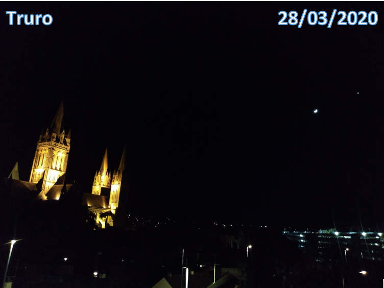
Back in 2020 Mayes Creative ran a bit of a bonkers project where I asked you all to take photographs of Venus and the Moon wherever you were in the world. We had lots of people take part and loved how enthusiastic everyone was about joining in. One of these was the late eminent astronomer Jay Passachoff who had written about the method that could be used to measure the distance from Earth to the Moon.
I had been fortunate to meet Jay and hear all about his travels to see solar eclipses at a Society for the History of Astronomy Conference in 2018 and have been saddened to hear of his passing this week. He was always very encouraging of grassroots astronomy.
So I feel blessed to have had his support with this fun socially interactive project. Here is how what we did to measure the distance to the moon and the results we obtained.
The idea was to re-enact the historical ‘Transit of Venus’ which astronomers travelled around the world in order to measure the distance to the Sun using parallax. We attempted the same thing but with the Moon and Venus using social media with people sending their images back to us digitally. Once all the images of the Moon and Venus were received we worked out how to get a distance to the Moon using similar historical techniques. This was done by photographing the position of the crescent of the Moon in relation to Venus, as this would change depending on where you were positioned on the Earth. Over the past 3 months, we had great responses from around the world which enabled us to measure the Moon’s distance.
We wanted to report back on how close a result we got from our ‘Measure to the Moon’ parallax project.
February – the first event/ trial run.
We had a good response but mainly from the UK, the furthest image we had to use as a baseline for the Parallax was from Portugal, we saw this as a trial run. The resulting distance we calculated was 271,734km and the Moon was 360,461km away from Earth, so we were a whopping 24.6% out.
March – the second event.
We had many images for the March attempt, including some from the Abu Dhabi Observatory and also the Philippines which really helped us get a better idea of the parallax shift. This resulted in a calculated distance of 340,014km, the Moon at that time was 357,122km away so just a 5.03% difference, which we thought was pretty amazing.
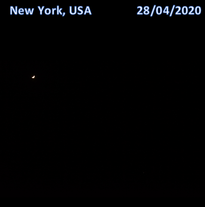
April – the third/last event.
The final attempt in April was marred by clouds here in the UK, although there were clear skies in the South-West. We did have a number of US observers taking part including members of Flagstaff and Jay Pasachoff in New York – making the project international. We got a resulting distance of 315,736km, the Moon at this date was 356,906km away, so we had a difference of 11.5% – pretty respectable.
So overall the March attempt had the closest result due to the number of photos we received from all over the world. There were lots of lessons learnt along the way, but we were pretty pleased with the results. We really enjoyed this and may run something similar in the Autumn involving Mars.
A Mayes Creative intern wrote a short computer program which scale-plated all the images and came up with averages. Then made all the calculations with guidance from astronomer Carolyn Kennett.
If you have enjoyed this maybe you would like to check out the following which eminent astronomer Jay Pasachoff shared with Mayes Creative.
Pasachoff, Jay. M., Gährken Bernd., and Schneider, Glenn., (2017), “Using the 2016 transit of Mercury to find the distance to the Sun,” The Physics Teacher 55, 3 (March), 137-141: cover illustration plus article: http://doi.org/10.1119/1.4976653