Carn-men-ellis Kerbed Cairn – Notes from the 2021 Equinox
SW 3481 2602
Latitude: 50.075005N Longitude: 5.707763W
50°04’30.0″N 5°42’28.0″W
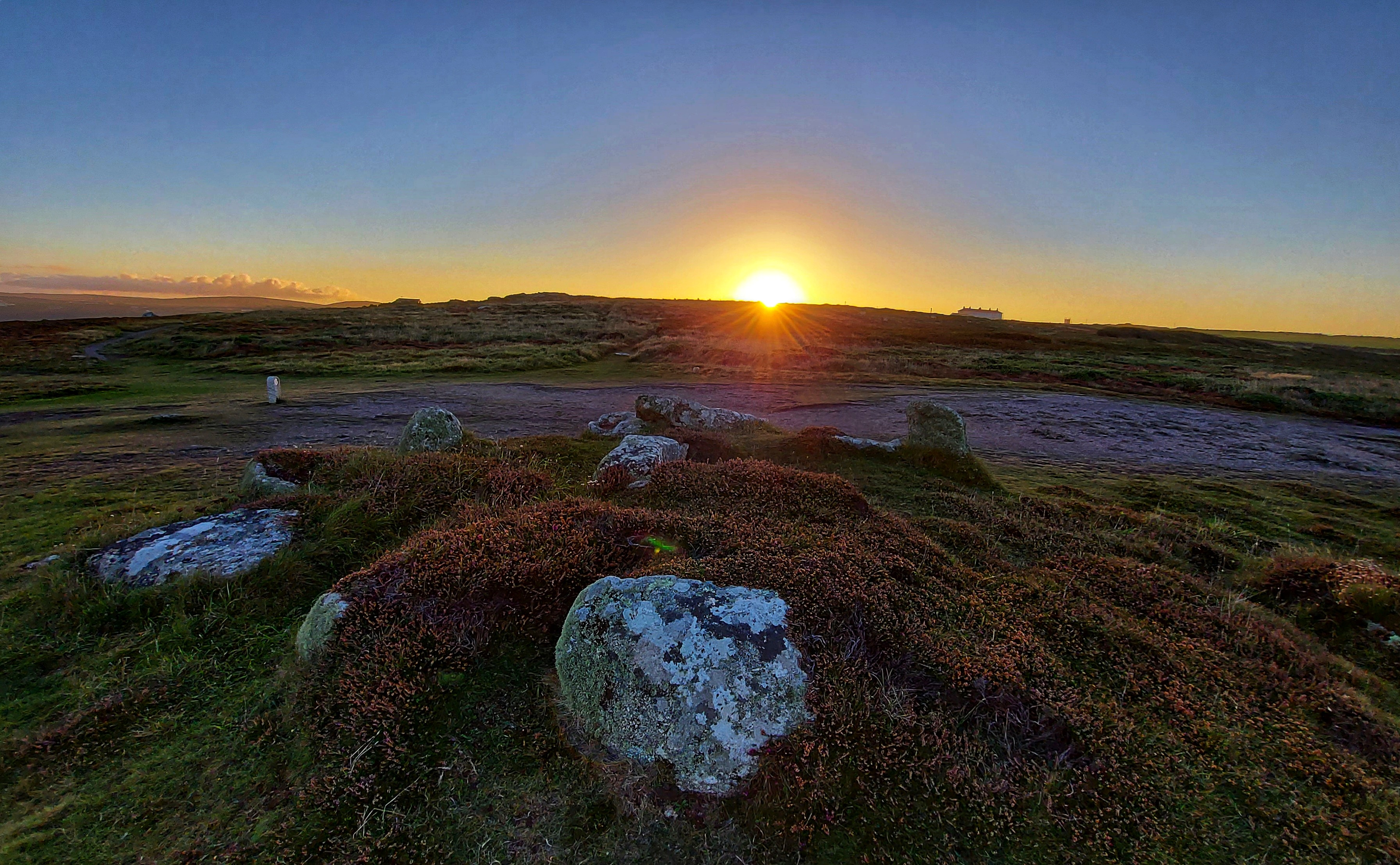
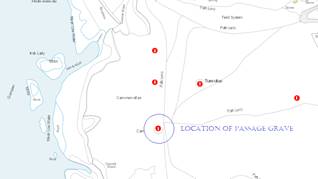
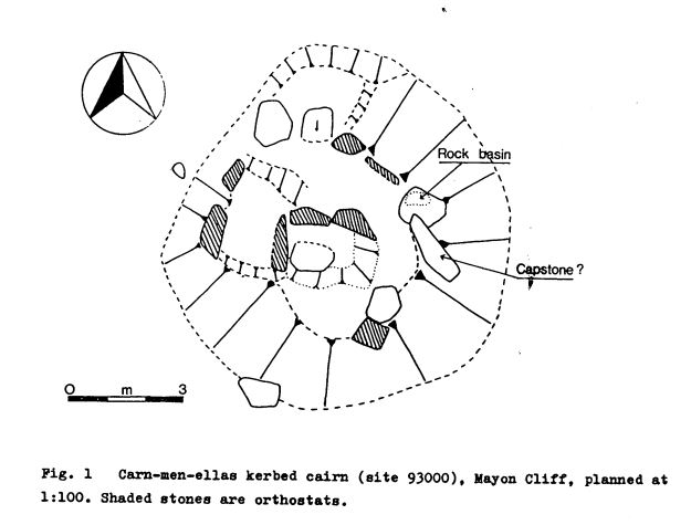
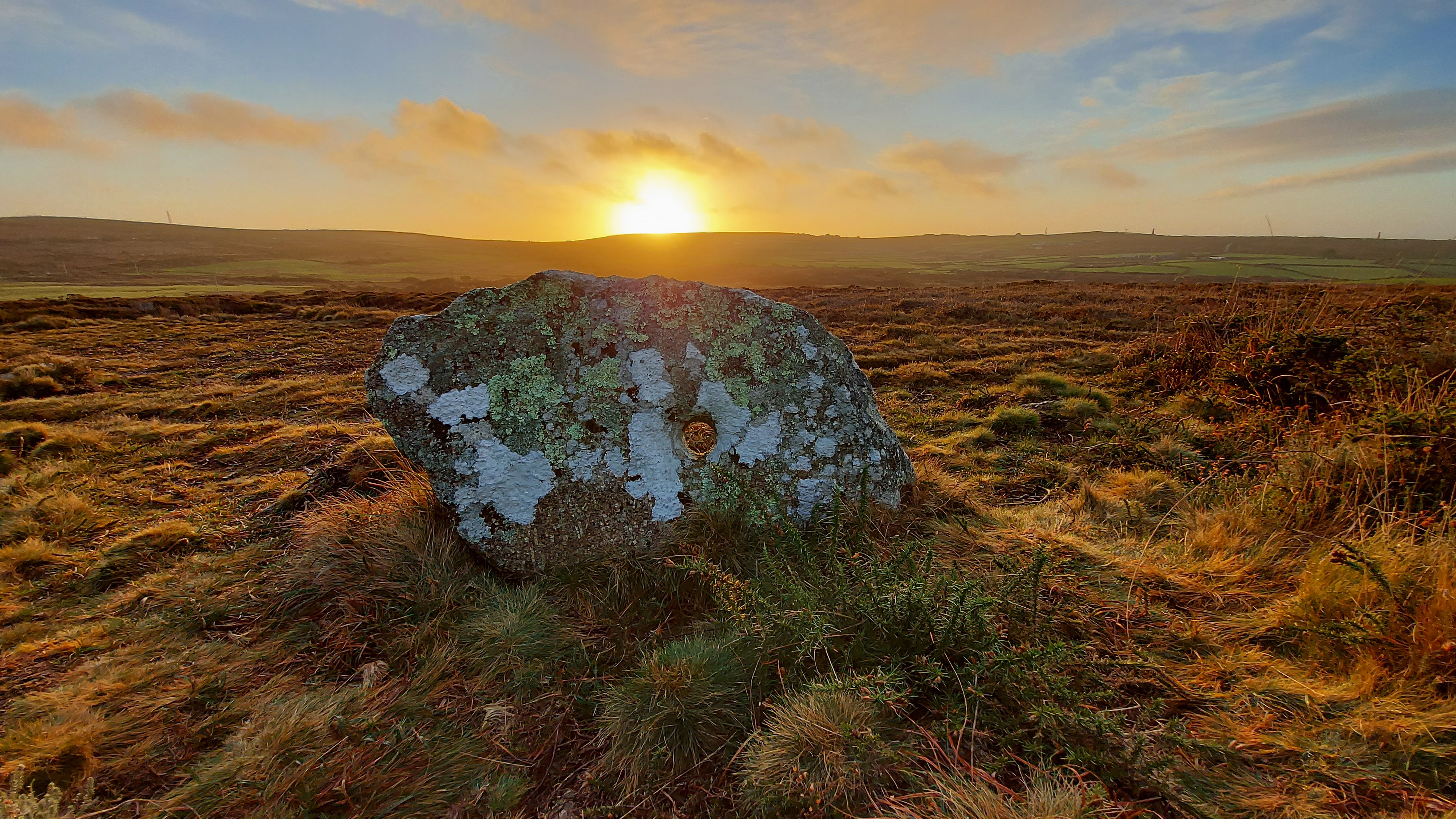
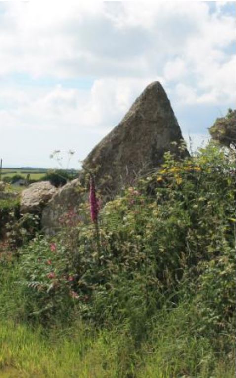
On the cliff top leading to Land’s End above Sennen are the remains of an intriguing prehistoric site known as Carn-men-ellis kerbed cairn (and cist).
This monument is dramatically positioned overlooking the western edge of Cornwall, with Land’s End visible to the south and Cape Cornwall to the north. On clear days, the distant Isles of Scilly can be seen on the horizon. The site itself sits on a gentle slope descending from east to west. In the immediate vicinity are four cairns, including one particularly impressive example that stands prominently on the north-eastern skyline. To the south, on the headland, lies the later-built promontory fort known as Mayon Cliff Castle.
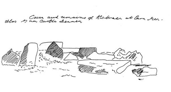
The monument has also been described as a Scillonian-style passage grave or chambered cairn, comparable to those at Tregeseal or Bosiliack. This one was excavated in 1879 by William Copeland Borlase, who recorded no finds. An early sketch of the site survives in the Morrab Library. The artist remains unknown, though it may have been commissioned by Borlase.
Sketched late 19th Century (Morrab Library, Misc. Pap. 44(1). Pl (17)). Possibly before Borlase excavated the site in 1879, as the dark shaded upright to the centre left was prostrate in later drawings, including a 1917 sketch by Charles Henderson below.
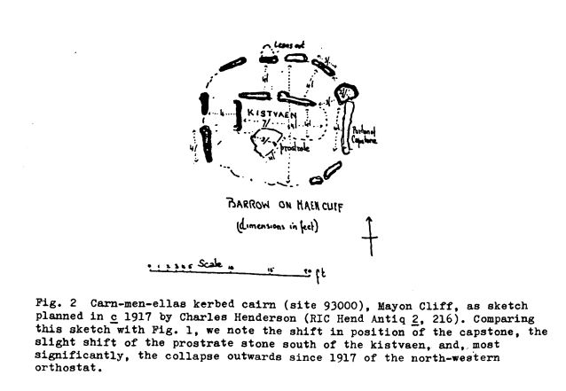
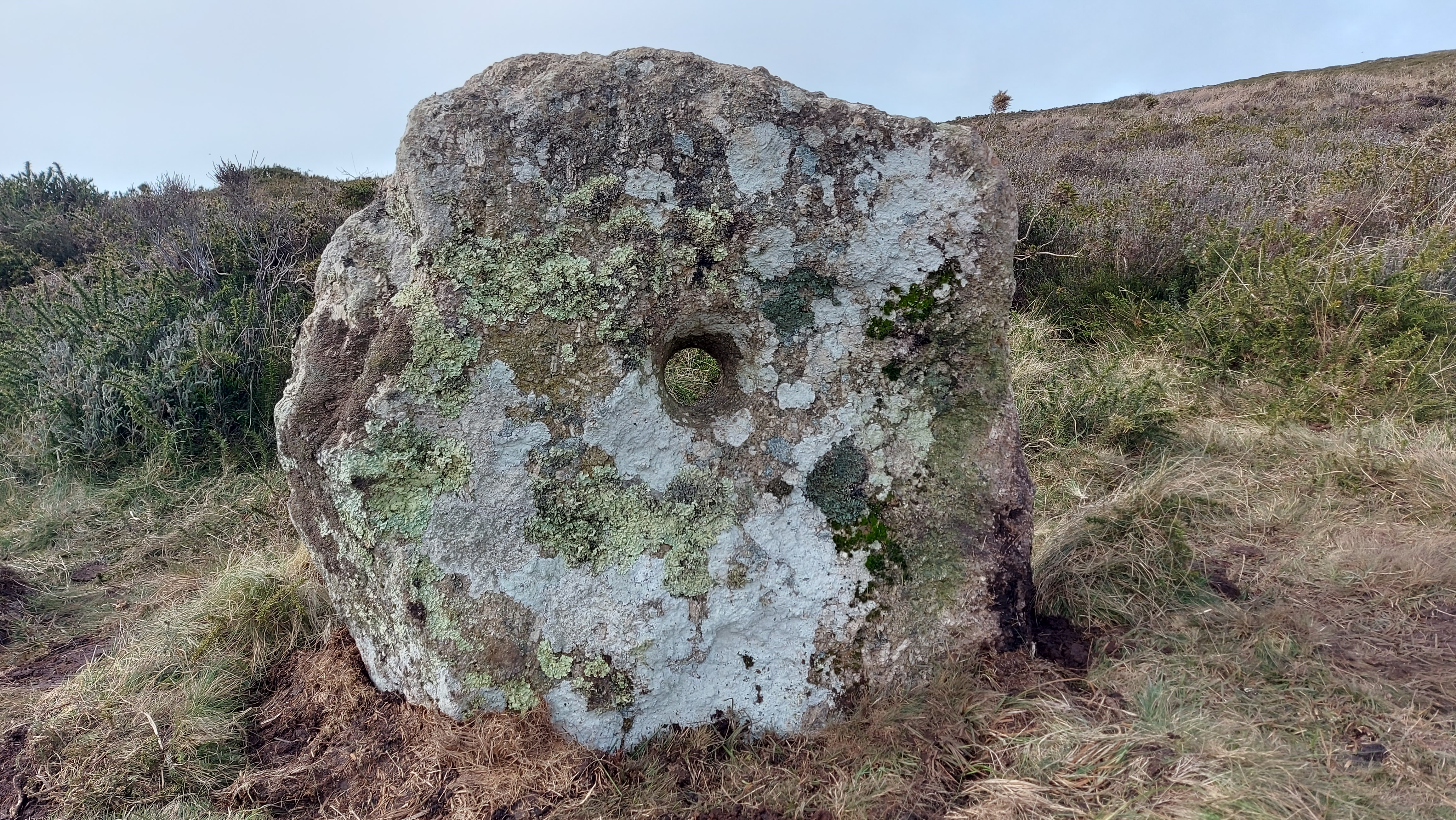
The grave was later sketched by Henderson in 1917 who labels a capstone and shows the kerb and central cist in plan form. A later assessment from the 1980s shows the moving of the capstone, an interesting stone with a rock basin and the remains of the central cist/passage area and kerb stones. This site is pretty much in the same condition as it was in that sketch.
In a 1983 survey report for the National Trust, Pete Herring suggested that the monument may have functioned as a territorial marker, a place where communities gathered for ceremonial events. A ritual or sacred centre where people gathered and sat with “their backs to the walls” of the chamber. (Barnett 1982, 49).
A rock basin is found on one of the stones; this would have formed by natural processes. Other rock basins have been incorporated into ancient sites. They may have signified ritual spaces as they could have been used perhaps for water collection, and maybe reflection of the face or sky, etc or adding other liquids like oil to light?. The Mȇn-an-Tol circular-shaped stone is an example of a rock basin utilised in a monument.
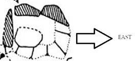
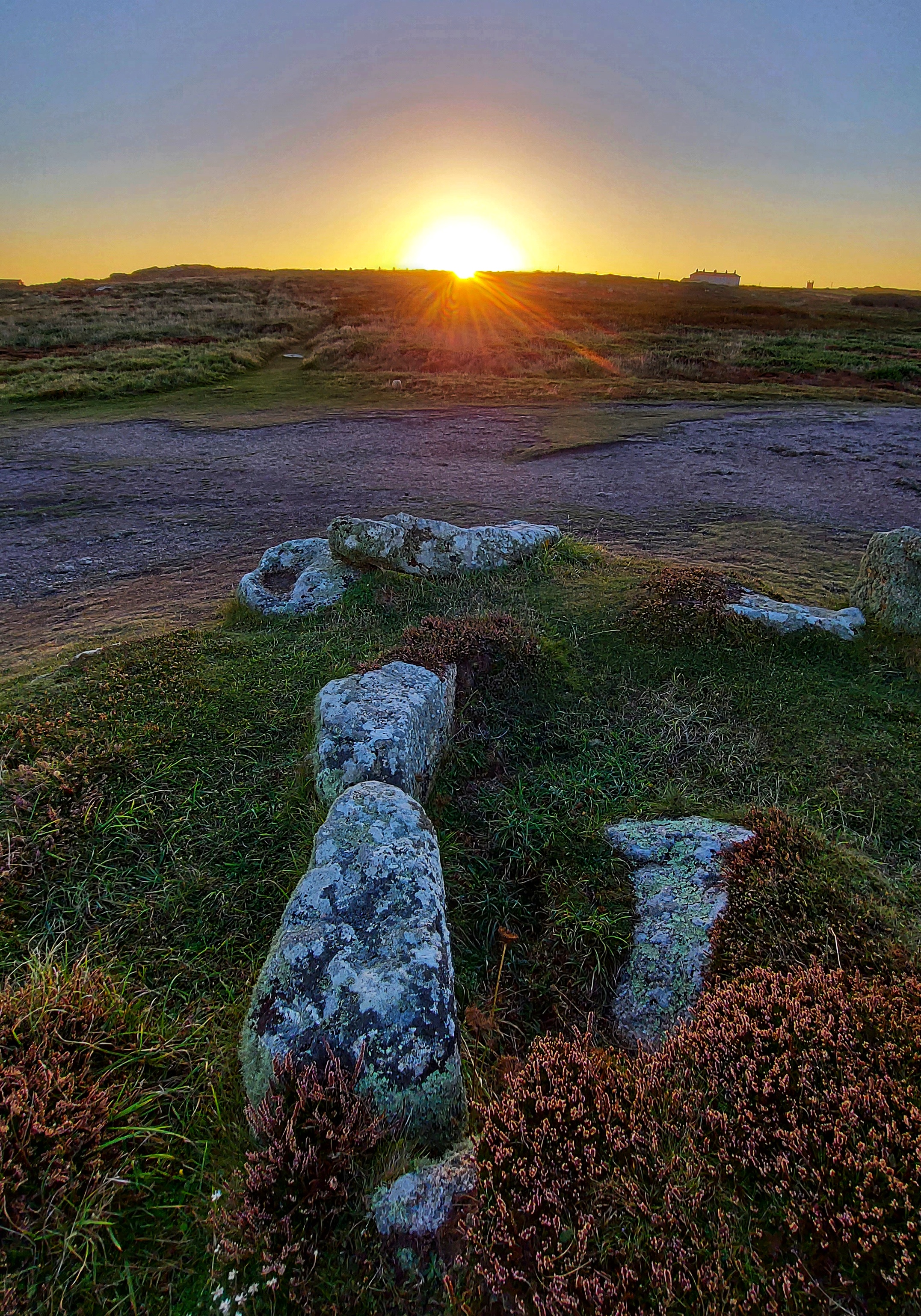
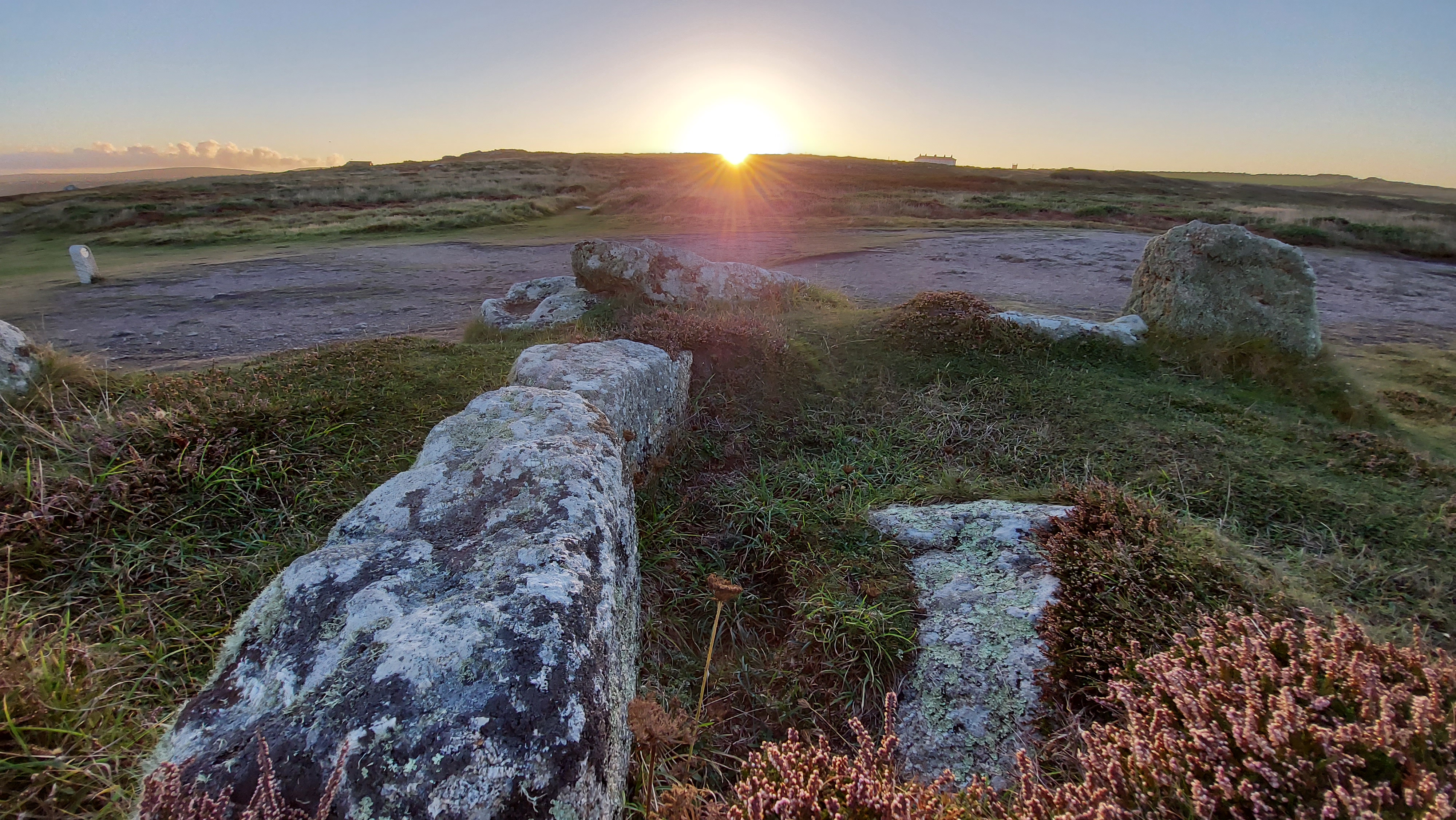
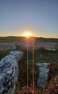
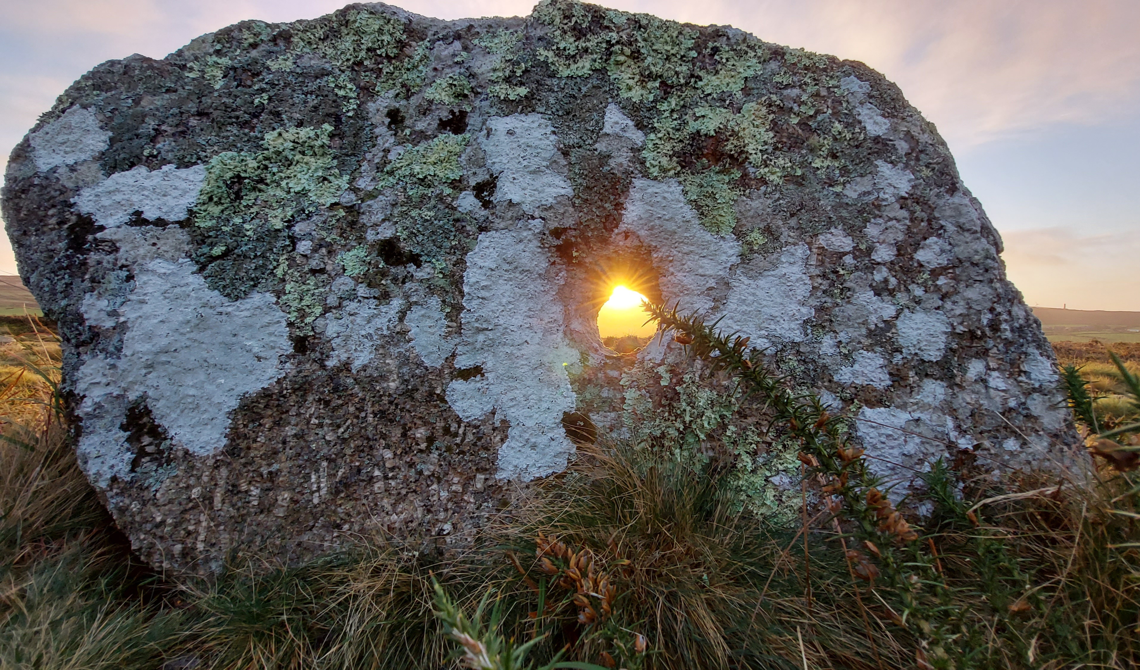
A personal visit to the site at dawn near an equinox revealed a possible alignment. The rising sun shines directly into what would have been the passage or chamber of the tomb as the back slab and chamber are oriented toward the eastern horizon. Two side stones, still in situ on the northern side of the chamber, appear to define a passage. One tapers southwards and may have restricted the light entering the chamber, like the arrangement at Treen South barrow.
This eastward orientation, which lets the sunlight enter the chamber at the equinox, is a feature shared with several other Scillonian passage tombs, as recorded by Katherine Sawyer and Paul Ashbee in their studies of sites on the Isles of Scilly. Ashbee observed that a significant number are aligned toward the eastern horizon, more so than in any other direction. Sawyer contended with 15% were facing E-W, out of 55, which could be accurately surveyed. Perhaps not an overwhelming picture of one direction proving more significant, although this was still the strongest favoured direction alongside the nearby facing ENE-WSW chambers making up 16%.
Back to this site both Henderson’s and the later CAU drawings show a site which is orientated to the eastern horizon, away from the western coastline and inland. The orientation of the chamber when it was measured was recorded at 90°.
At this location, the sun rose on the morning of the 20 September 2021 at 7.29 (BST) with an azimuth 91°56’43.3. It needed to reach an altitude of 3°07’50.2 to rise above the ridge of the local hill.
The images were taken 2 days adrift from the mid-point in the solar cycle.
Adjusting these two days to the mid-point (equinox), it would rise above the ridge at an azimuth of 93°09’38.3
A difference of 1°12’55.0 or a displacement of 2 solar widths to the south (to the right in image as shown below)
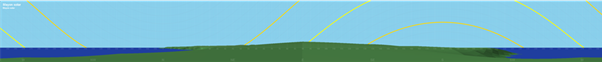
Visualisation of the displacement of the sun along the horizon, between the photo date and mid-point sun (equinox) date, as seen from the rear of the chamber.
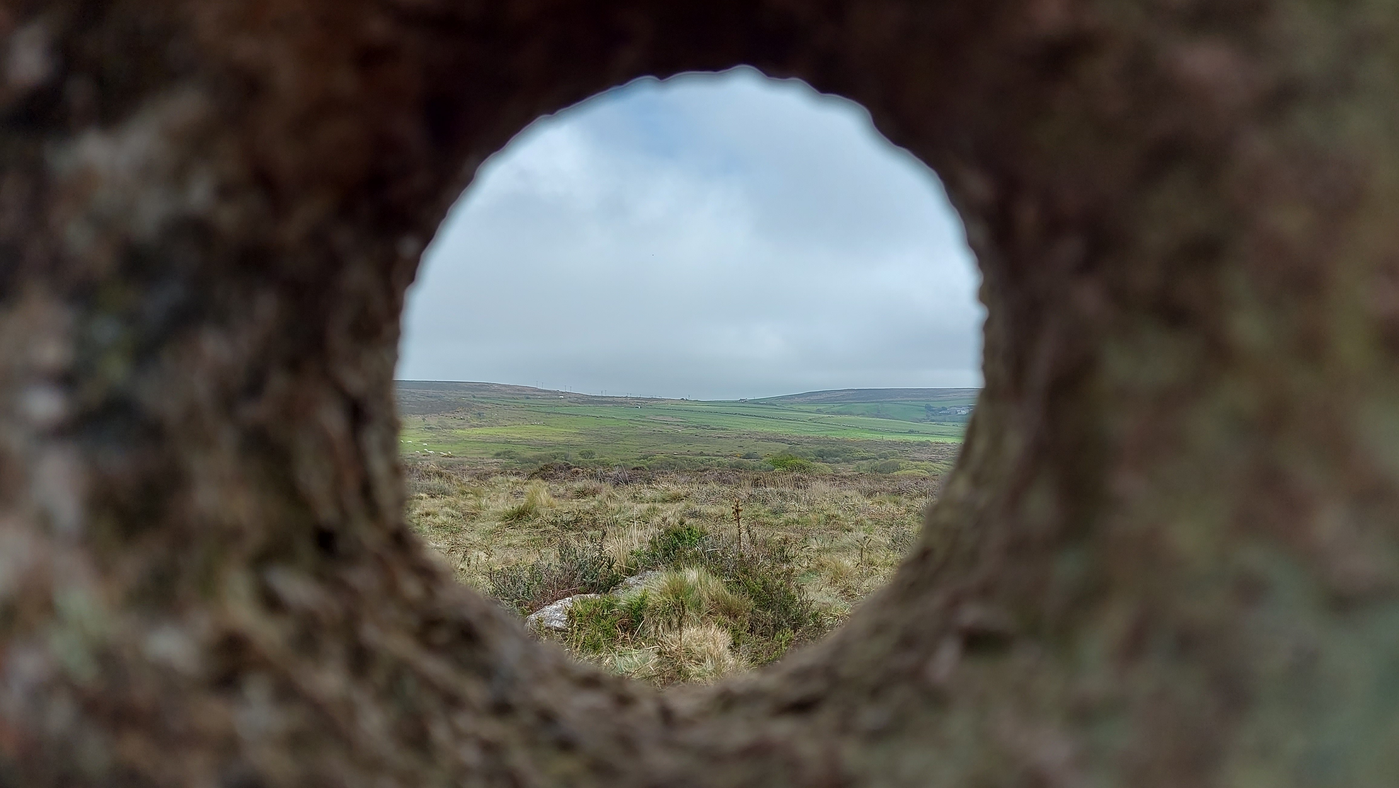
With the limited amount of information we have about the entrance area and size/possibility of an entrance passage, we can only surmise that the sun would shine directly into the chamber area for at least 2 days, either side of the mid-day sun.
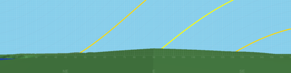
Solar rising and setting positions
Apart from the orientation of the barrow towards the eastern horizon and the mid-point rising sun. It is worth looking at its situation in the landscape with respect to the extremes of the solar cycle. Much of the horizon is distant seascapes. The Isles of Scilly make an appearance as and when conditions allow; they lie on the WSW at an orientation of 245-257°.
Only the sunrises at the solstice and the midpoint occur over land. Of these, the summer solstice sunrise is of interest as it occurs over the distant Bartinney Hill, which has an enclosure and cairns at its summit. This prominent hill has extensive views throughout the western part of Penwith. Also visible is Chapel Carn Brea. This is located just to the south west of Bartinney and can be seen in the photos adjacent to the localised ridgeline.
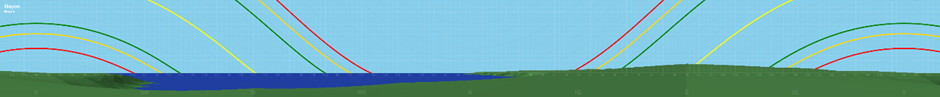
Horizon detailing the rising and setting positions of the sun at solstice and the mid-point.
Section of Horizon showing eastern view
The yellow track is the solar position at mid-point and solstice, red and green tracks are the moon at standstill positions
Barnett, J (1982). Prehistoric Cornwall p49
Sawyer, K (2015). Isles of the Dead p59
Herring, P (1986) The National Trust Archaeological Survey, Maen Castle and Lands End p25
As the darkest of nights draws ever closer and the hours of darkness deepen. We can take comfort that the night is no empty space, the heavens open up for us and at this time of year our ancestors in the Bronze Age would have seen a great river of stars, now known as the Milky Way, arching across the sky above them. The Milky Way has long been both a boundary and a bridge. Across cultures its silvery light holds a shadow of darkness, imagined as a pathway for the dead or a dividing line between lovers. In prehistory it was likely seen as a place of wonder and story, perhaps a path trodden by gods and giants. Perhaps those who carefully set stones as a link between the circles at the Hurlers in Cornwall, or on the ground next to the towering monoliths of Dartmoor’s Piles Hill, sought to mirror the heavens upon the earth. In doing so, they brought the stories of the stars within human grasp, creating an opportunity for transcendence by reaching out to touch the world beyond. In Wales, the children of Dôn knew the Milky Way as Caer Gwydion, the castle of the trickster who strides across the firmament in pursuit of his elusive wife. And in that lost sky we may find the shadow of his companion, Bran the Blessed, raven-king of night. His presence remains in the Cornish hills at Mȇn Scryfa, a solitary menhir inscribed with memory of a royal raven, and at Caer Bran, the hillfort that bears his name. I like to think these are more than places of earth and stone, but gateways, places we may stand and look upward and perhaps trace the crow’s path along the starry river. The dark skies, once alive with ancestral stories, are no longer what they were; they have been dimmed by our lights. Where once every soul knew the sweep of stars, now only a few of us get to glimpse the Milky Way. True darkness has grown rare. Yet we are fortunate in Cornwall, where it can still be found arching across the sky. To stand at Caer Bran or Mȇn Scryfa on a clear, moonless night and watch the Milky Way blaze forth is to walk another time perhaps beside the raven.
Back in May I was kindly invited to speak about the wonderful Cornish ancient sites on Bodmin Moor and the research I have been doing into the relationship they have with the sky. Here’s a link to the talk,
Written after the April 2023 archaeological investigation of the stones
Adjoining the ritual landscape of Tregeseal near St Just, Cornwall lay a curious collection of stones known as the Kenidjack Holed Stones, which are named after the common land on which they are sited (Latitude 50.1360°, Longitude -5.6537°). The site consists of four large granite slabs each perforated with a circular hole currently positioned in a row with an ENE-WSW orientation of 67°, with a further fifth smaller holed stone a few meters to the NW of the main row. The stones are distinctive due to being a collective group with holes, and while there are other examples of holed stones in west Cornwall (including a number near the Merry Maidens stone circle), it is unusual to find a group of them together. It is considered that they are most likely a collected monument which relates to the local Bronze Age barrows, stone circles and other monuments within the immediate location. They were drawn in 1842 by John Buller laying prone on the floor.[1] All the stones have likely fallen and been re-erected a number of times. In 2020 one of the stones became loose and fell over, the hole in which it had sat was very shallow and although it was propped back up it needed to be reset in the ground in a more robust manner. By 2023 a second stone was also becoming loose and this led to the opportunity to examine if there was any evidence of their original positions in the ground immediately surrounding them or if these had been lost. The archaeological investigation was led by Peter Dudley of the Cornwall Archaeological Unit with support from Laura Ratcliffe-Warren and a team of volunteers from the Penwith Landscape Partnership. Historic England grant-funded the work as part of the monument management programme of conservation works.
The monument consists of the four larger stones in the row and a further outlier stone to the main row. The stones in the row have been called A-D for the purposes of this investigation (with E being the outlier). Three stones in the row are upright while the fourth lays prone and broken with only half of its hole still visible (as it was drawn in Buller’s early sketch). The smallest holed stone is an outlier to the NW of the row and has likely been moved from its original position and re-erected with a viewpoint of the outcrop of the top of Carn Kenidjack in mind. It was photographed in 2010 broken in two and has been reset in its current location.[2]
Image: Stone Row with each stone labelled from A – D
Credit: Carolyn Kennett
Stone A and Stone C were subject to the archaeological investigation conducted over two days in late April 2023. Two separate 1.6 x 1.2m trenches were opened up in the immediate area around stones A and C before both were replaced in the same position as before the conservation works. In an effort to make stone C more secure it was reset with its long edge into the ground and short square edge at the top. The chosen side being matched to Charles Henderson’s 1922 drawing of the stones.[3]
Image: Stone C following the 2023 conservation works
Credit: Carolyn Kennett
There was no evidence of any original setting or ground disturbance relating to Stone C. In Charles Henderson’s drawing, he has this stone positioned closer to Stone D and this could be the reason that no ground disturbance was found.
Beneath the location of Stone A the team uncovered the edge of a possible large pit or hollow, with a fine greasy layer at its base. From its texture, the layer was possibly organic-rich in its composition. Within this was a discarded rough flake of flint (also burnt), knapped off from the outer edge of a flint nodule. It is difficult to date the pit/hollow, especially considering the later changes to the monument. It could potentially date from the erection of the monument and perhaps indicate that there was a fire in the vicinity of the stone, however, without full excavation, a fuller understanding is difficult to establish. Care was taken not to change the orientation of the stones although Stone A was buried approximately 20cm deeper than it had previously been to ensure its long-term stability.
It was concluded that the monument had undergone disturbance in both orientation and original positioning of the stones. The earliest description of the stones has them positioned in a line and there is nothing to suggest they would have stood in any other way. The 2023 archaeological investigation found little indication of their original position. Therefore the following is a suggestion of what may have proved interesting about the holes and related skyscapes at the site during the Bronze Age, rather than a definitive conclusion about the orientation of the stones, holes and related skyscapes. This examination tentatively discusses the possible role of the holes in their relationship to the cosmos while taking into account the challenges of orientation.
Looking directly through the holes
Image: Sunrise through stone D, 17th December 2021
Credit: Carolyn Kennett
The stones are located on the side of an eastern slope leading up to Carn Kenidjack and keeping this feature in sight at the monument may have been important in the choice of location of the row. Each hole is positioned low on the stone and the rise in slope makes it impossible to observe the sky when looking towards Carn Kenidjack through the holes, and you can’t see the sky in this direction. Looking through the holes in the opposite direction gives a slightly different view of the southeast horizon, as the stones are each positioned at a different angle in the row. Due to the aspect of the site and the rise in slope, it makes more sense that any observations of the sky made through the holed stones would be limited to this general direction. The current orientation gives sightlines through the holes with azimuths between 105° and 135°. This relates to rising objects of the celestial sphere and it is possible to see the sun, moon and a number of stars in this direction as they move through their celestial cycles. The stones could have been orientated to watch for seasonally important sun and moon rises or helical-rising stars maybe marking chosen calendrical events.
Image: Horizon positions which are observable through the holes (pre-archaeological investigation)
Credit: Carolyn Kennett
Image: Profile of horizon (horizon scale exaggerated x7)
Credit: Graphics by HeyWhatsThat
After the investigation, Stone D’s orientation to the furthest southeast part of the horizon remains unchanged. Stone C was orientated towards the ESE, resetting the stone hasn’t changed this orientation by much and it still faces the lower ground between the two ridges on the horizon.
Image: Horizon view through Stone C following the 2023 conservation works
Credit: Carolyn Kennett
Stone A is orientated centrally of the three. This orientation changed little after the stone was reset and still was centred on the distant southeast ridge. When looking directly through the holes at the horizon there is a crossover with Stone C and D’s views.
Image: Horizon view through Stone A following the 2023 conservation works
Credit: Carolyn Kennett
The sun and the holes
The sun changes its rising position throughout the year, rising directly in the east at the equinox and furthest to the northeast for the summer solstice while rising at its furthest point to the southeast at the winter solstice. If the stones were orientated in the way they are today there would have been times when the sun would rise and shine directly through the holes. Could the holes be used to observe the rising sun through them?
Image: Sunrise through stone A, 1st December 2019
Credit: Carolyn Kennett
The location of the holes low to the ground gives an uncomfortable observing position and looking directly at a rising sun is fraught with danger as the sun can cause serious damage to the eyes. There is an alternative way in which the sun, hole and stone could work in unity. Instead of looking directly through the hole, an observer waits until after the immediate sunrise for a shadow to form behind the stone. The shadow only takes minutes to form after sunrise and if the stone is orientated to a corresponding part of the horizon where the sun rises a beam of light shines through the hole onto the ground.
Image: Sunrise through stone A, 6th December 2020
Credit: Carolyn Kennett
The rising sun will form a circular sun beam onto the stone’s shadow. The connectivity between the sun, stone and shadow may have been of interest to the people who created the holes in the stones. As a phenomenological effect, it could have been perceived as a mastering of the sun itself (a possible deity) by casting it down, bringing it to earth while shrinking it and harnessing its power and warmth at ground level. I can speak from experience when I say that the concentration of sunlight shining through the hole is a great way to warm your hands on a cold morning! Alternatively, It could have been seen as a demonstration of light overcoming darkness, with the sunbeam forming centrally in the dark shadow behind the stone.
Image: Sunbeam shining through the hole captured onto a piece of card
Credit: Carolyn Kennett
The sunbeam is an ephemeral, time-sensitive feature. It would only be visible within the shadow for a number of consecutive days, for a few minutes at a time. All the holes are of similar diameter and in theory this would allow the holed stones to be used as a rough calendrical device from the number of days the sun would shine through the hole. If the holed stones were standing similarly to their current positions then each hole aligns with a different set of sunrises which partly overlaps because of the view of the horizon through the holes.
The angular diameter of the sun, corresponding hole and distance to the eastern horizon means that the sun would shine directly through the holes for approximately 20 consecutive days (there is some discrepancy in this as the daily displacement of the sun is not uniform during the solar year). In their current positions Stone C correlates to the sun rising from early November to late November, stone A corresponds to dates from late November to mid-December and Stone D relates from early to late December including the rising sun at the winter solstice. There is a large crossover in dates between Stone D and Stone A and the people who positioned the stones may have purposely made the sunbeam shine through multiple holes with the overlapping highlighting more significant dates.
Stone B may have filled in the gap in sun beams and acted as a midpoint between Stones C and A. Stone D’s orientation includes part of the horizon which is too far south to see the sunrise during the annual cycle. In its current position, the rising winter solstice sun would be a central feature to the hole. It is unlikely we will ever know the orientation of stones but if they are any way similar to their position today they could have acted as a calendar and functioned (with the other prone stone) as a countdown signal perhaps to the winter solstice,.
Image: Sunrise through Stone C, 1st December 2019, at this angle the sun no longer shines all the way through the hole
Credit: Carolyn Kennett
The first linked sunrise would occur around the cross-quarter period known as Samhain and a time to harvest, while the final holed stone is centred around the time of winter solstice when the sun reaches its most southerly position. The holes would unlikely have been used as an accurate dating tool, instead, it could have been a method of honouring the importance of the sun at this time of year. Capturing and ground casting the sun during the darkening of the seasons could have been seen as significant. The other monuments in the immediate locale have connections to the winter solstice festival. Tregeseal passage grave in the valley below is orientated to the winter solstice sunrise and contained a cross-based urn linked to solar symbolism.[4] Furthermore, the Tregeseal stone circles are focused on a sea gap which incorporates a liminal view of the Isles of Scilly 26 miles off the coast and the winter solstice sun sets in that direction when observed from the circles. Locally the Neolithic Chûn Quoit has an alignment to Carn Kenidjack suggesting this was a longstanding important location to mark the winter solstice.[5]
Observation of light beams in shadows allows people to observe the sun indirectly, while not hurting the eyes as would occur with direct observation, much the same way pinhole projection is used today within astronomy. This method may have been used at another holed stone in Cornwall, through the hole in the capstone at Trethevy Quoit. When the sun reaches its zenith during the summer months it rises high enough in the sky to shine directly through the hole casting a sun beam onto the ground below. This occurs on the summer solstice at noon (UT).
In theory, the full moon could work in a similar way to the sun, shining moonlight through the holes onto the shadow behind the stones and could relate to different full moons as it moves through its phase cycle. The full moon is working in opposite to the sun, being reflected sunlight, so the time of year it would be shining through the holes at full would be in the summer months. In many ways, the full moon in the summer months is less significant than that of the winter full moon. The daylight hours in the summer are much longer and the full moon rises and sets low in the southeast making less of a visual spectacle than in the winter months. It is not rising high like in the winter months, where the full moon played a role in bringing more light to dark nights. At the holed stones latitude of 50.136°, there is little astronomical darkness around the summer solstice and the moonlight would be diffuse and dim and unlikely to cast a moon shadow or light through the hole. It seems more likely that the rising sun would be visually impactful and significant.
Helical-rising stars and seasonal timing
Helical-rising stars have been used in many societies to set dates and festivals. This is a significant moment when a bright star can be seen rising in the morning for the first time before dawn light drowns it out. The motion of the Earth means that stars are seasonal and they rise approximately 4 minutes earlier each day. At times of the year, certain stars are not visible and their return to the night skies can herald the start of a season. The return of Sirius to the skies was used in such a manner by Ancient Egyptians, while the star group the Pleiades were used in this way in Ancient Greece.
The stones could have been positioned to watch for certain helical bright stars rising. This would involve the observer laying prone observing the night horizon directly through the hole. The horizon in this direction is fairly uniform, it has an elevation of 1.2-2.2° above 0. As the stars would be observed low to the horizon a person would be looking through a thicker layer of atmosphere and the light travelling from the stars would be scattered making them hard to see. Therefore only the brightest of stars would be observable at these low elevations. The holes could in effect help by limiting the view. If you hold up your hands in front of you and form a circle in which to look through you will note that you are narrowing your perspective to a more focused view, it’s an optical illusion but could aid with sharpening the view. Looking through the holed stones creates the same effect as you narrow your worldview. The only stars visible would have an apparent magnitude 1.5 and brighter. Star’s positions change due to precession. For instance, the bright star Sirius would rise at this latitude with an azimuth of 125° in 1500BC and 131° in 2500BC, as there is no accurate date from the monument this means that stellar objects over a wide range of declinations have to be considered.
The holes correspond to a horizon range which covers the rising positions of celestial objects with declinations between approx. -10° and -35°. Following is a table with bright stars observable at this latitude. The yellow highlighted ones have orientations which correspond and could have been seen to rise within one of the holed stones during the early Bronze Age period of 2000BC.
Star
Apparent
Declination
Declination
Declination
Declination
Declination
Right ascension
Name
Mag.
3000BC
2500BC
2000BC
1600BC
J2000
J2000
Sirius
-1.46
-22°21’15”
-20°42’47”
-19°16’55”
-18°17’55”
-15°25’28
-18°17’55”
Arcturus
-0.04
48°33’57”
45°44’31”
42°47’42”
40°22’44”
21°24’54”
14hr21m0s
Vega
0.03
43°59’58”
42°36’06”
41°23’05”
40°32’46”
38°26’25”
18hr36m20s
Capella
0.08
26°10’08”
28°53’10
31°33’38”
33°38’33”
46°26’38”
5hr15m40s
Rigel
0.12
–25°37’54”
-23°04’02”
-20°37’32”
-18°46’39”
-8°12’04”
5hr14m31s
Procyon
0.38
2°58’48”
4°31’55”
5°49’32”
6°39’36”
6°15’46”
7hr42m56s
Betelgeuse
0.5
-7°27’02”
-4°57’60”
-2°38’03”
-0°53’50
7°23’45”
5hr55m1s
Altair
0.77
9°58’52”
8°34’10”
7°25’26”
6°42’35”
8°28’33”
19hr48m0s
Aldebaran
0.85
-4°46’48”
-2°02’23”
0°39’18”
2°45’17”
16°42’25”
4hr35m35s
Antares
0.96
-4°08’35”
-6°55’16”
-9°40’28”
-11°50’08”
-26°24’23”
16h29m26s
Spica
0.98
14°42’23”
12°35’39”
10°16’60”
8°18’55”
-11°07’23”
13hr25m24s
Pollux
1.14
22°51’10”
24°49’07”
26°31’51”
27°41’40”
28°11’30
7hr48m56s
Fomalhaut
1.16
-43°58’06”
-44°11’06”
-43°57’28”
-43°27’45”
-29°25’25”
22hr55m50s
Deneb
1.25
36°30’34”
36°28’47”
36°39’38”
36°57’23”
45°16’43”
20h41m25s
Regulus
1.35
23°36’39”
23°55’41”
23°52’48”
23°34’45”
11°54’50”
10hr09m41s
Adhara
1.5
-33°38’01”
-32°09’34”
-30°53’29”
-30°01’54”
-28°58’24”
6h58m36s
Castor
1.57
24°51’48”
27°00’26”
28°54’51”
30°14’31”
32°04’45”
7hr35m40s
Pleiades
1.6
0°05’22”
2°49’59”
5°36’07”
7°48’42”
24°22’03”
3hr45m49s
Only three stars are considered to be close matches to the holes, these are Sirius, Rigel and Adhara and due to the little correlation between the brightest stars in the sky and the position of the holes, it seems very doubtful that they were used to observe helical rising stars.
To conclude, if the holed stones were used as observational tools the most probable method would be linked to viewing the sun. It seems most likely that the best method for doing this was watching for the beams of light to be cast through the holes made by the rising sun. It’s dramatic watching the beam of light illuminate the shadow cast by the stone and I really recommend getting up on a winter’s morning to witness this if you get the chance.
Image: Sunrise 17th December 2020
Credit: Carolyn Kennett
[1] Buller, John (1842) A Statistical Account of the Parish of St Just in Penwith in the County of Cornwall. Dyllansow Truran p. 100
[3] Charles Henderson’s 1922 sketch of the stones (taken from the 2011 report on the conservation works to the lone stone – Preston-Jones, A, 2011. Kenidjack holed stone, St Just, Cornwall – repair and restoration. Truro: Cornwall Archaeological Unit, 2011R119)
[4] Kennett, Carolyn (2021) Burying the Sun, Crossed Based Urns and Solar Symbolism. Astronomy Yearbook, White Owl Press. p 152.
[5] Kennett, Carolyn (2021) Tregeseal Circles and the Solstice Sun. Meyn Mamvro Vol 2. No 3. pp.8-10.
In late 2019 I was part of a small group of enthusiastic scientists and historians who came together to discuss their love of Cornwall, the history of astronomy, old scientific instrumentation and the life and work of George Biddell Airy (1801–1892). As a group we were struck by one central aspect to our interests: his Cornish Dolcoath Mine Experiments of 1826 and 1828 to measure the density of the Earth. The discussion led us to devise a plan to get together in a Cornish mine to re-enact the experiment as close to the original as possible. It was an ambitious project and when we set off on this journey we could not foresee all the setbacks and delays that would hamper our efforts to reconstruct the experiment. There have been a number of times when it seemed an impossible task, but we kept moving forward, albeit in very slow increments at times and often with similar parallels that were faced by the original experiments. But before we reach the conclusion on our progress it is important to say a little about the experiment and the reasons why we are still determined to make this happen.
The Experiment The use of pendulums to measure the difference in gravity around the Earth was nothing new when George Biddell Airy and William Whewell set off to Cornwall in 1826. It had been known that the Earth’s gravity was variable since 1671 when the French scientist Jean Richer made measurements with a pendulum clock and discovered that gravity was not uniform and that it was running over 2 seconds slower in French Guiana than in Paris. In 1737 the French mathematician Pierre Bouguer swung pendulums at different elevations and from the rate of swing was able to make the first estimate of the density of the Earth. There was a lot of concern over the accuracy of these early experiments due to the difficulty in measuring the period of the pendulum. These concerns continued unabated until the invention in 1817 of a reversible pendulum by British Captain Henry Kater. The invention would offer the opportunity to measure the local acceleration of gravity with much more accuracy than ever before.
The experiment required the free-swinging pendulum to be hung in front of a tall grandfather-style precision clock and the timing of the swing would be measured against the clock-driven pendulum behind. To get a measurement for the gravity of the Earth you would need to run the experiment in two locations with different altitudes. Using mountains would be one option, but the mines of Cornwall offered another.
Dolcoath 1826 Dolcoath Mine in the early 1800s was the deepest mine in England. Known locally as The Queen of Cornish Mines it was located in the far west of England near Redruth. It was a very profitable working mine mainly extracting copper, but also tin, silver, arsenic and other minerals. By 1826 it was over 2000ft in depth, with its deepest recesses accessed by long series of ladders. Any equipment, mine spoil and occasionally men would travel up and down the large shafts in buckets called kibbles. The laborious activities would not be limited to the underground, on the surface were noisy pressing stamps and arsenic works which ran beside the engine house. These were working environments before the times of health and safety where accidents were frequent and life was hard for the men, women and children who made their living through mining.
The main way to get goods and occasionally people in and out of the mine – Riding the Kibble Credit: Mines and Miners. Louis Simonin, 1868 It was in this environment that the two scientists Airy and Whewell arrived first in the summer of 1826 and brought with them precious and expensive precision instrumentation to conduct a scientific experiment. What could possibly go wrong? Well, as it turned out, quite a lot! On arrival, two stations were set up, one underground and one on the surface (perpendicular above to the underground station). Two pendulums (named Foster and Hall after their previous owners) in the design of an invariable Kater one-second pendulum were suspended on knife edges and hung in position in front of a clock pendulum. Alongside the pendulums, they arrived with seven precious and valuable chronometers, tripods, telescope sights and tents.
The surface station was set up in a tent on top of a hill which rises to the south of Dolcoath mine while the subsurface location was 1200ft underground. The cavern in which it was located was split into two with a wooden screen. The experiment was placed behind one side of the screen and separated from the person who would watch the motion from the other side through a sighting telescope looking through a small hole in the screen.
Each pendulum swung for 6-8 hours a day while being watched by either Airy or Whewell, and then the timings were compared between the two stations. The chronometers were transported between both sites at the start and end of the experiment to compare with the clocks. There were some initial concerns. The stands were not up to the job as they were not stable enough. The fragility of the chronometers and lack of agreement between the timings of these was a major concern (two soon had broken glass, damaged from being carried up and down the ladders). It was decided to make the observation runs shorter – just 5 hours of observation a day – so they could compare the chronometers to the ‘clock’ more regularly with an ambition to lead to better accuracy.
After the first cycle of measurements was made there was an attempt to raise the Foster pendulum to the surface. At this point, there was an accident and the straw packing within the kibble caught fire and the bottom of the bucket burnt through. The pendulum plunged downwards and was lost to the abyss. Airy believed it was sabotage and certainly the miners could have been to blame. They were a suspicious lot, living in a remote part of the UK and working in a job where death was commonplace. The arrival of two scientists from London with their strange requests couldn’t have gone down well. At best they were seen as an inconvenience at worst they were regarded as the source of bad luck. Sedgewick encapsulates this in his accounts of the experiment “One morning I listened to two men who had watched our descent the day before: “I think they’re no good. There must be something wicked about them – the little one (that was Airy) especially. I saw him stand with his back to the Church, and make strange faces.” (Sedgewick, 1890)
Airy immortalised the moment of disaster in a poem The ladders of mighty Dolcoath I descended Through caverns that yawned like an entrance to hell:
All was silent, save when through the levels came blended The roar of the blast and the kibbul’s deep knell. To the right, a vile path round the South Shaft was bending: Behind, a chain-ladder from hooks was depending: Our station’s white door in the front was ascending: When I marked the sad spot where the pendulum fell. Dark and drear was the spot in Dolcoath’s deepest level Where the pendulum’s fragments were scattered around, As when, at the close of some drunken men’s revel, Broken bottles and plates encumber the ground Yet though scatter’d they lay, not entirely neglected: For the men who had packed them, with spirits dejected, And Mid Cattell and deads the small pieces selected, And sent up to grass all the bits that they found. Taken from George Biddell Airy, ‘Dolcoath’, in P. D. Hingley and T. C. Daniel (eds.), A far off vision: a Cornishman at Greenwich Observatory. ‘Auto-Biographical Notes’ by Edwin Dunkin, F.R.S., F.R.A.S., (1821-1898), with notes on the lives & work of his father, brother and son, (Royal Institution of Cornwall: Truro, 1999), p. 182.
Dolcoath 1828 After the ill-fated first attempt, Airy and Whewell would return in the summer of 1828. This time they arrived with reinforcements; the intention was to keep the experiment running twenty-four/seven. Accompanying them were the eminent astronomer Richard Sheepshanks and geologist Adam Sedgewick. They also had a number of additional helpers including Airy’s younger brother. In another change to the original experiment instead of bunking down in the local count house (now Miss Mollies Tea Rooms) they were to stay within the houses of local mine owners and aristocrats, the experiment had become in all ways something much grander. They arrived on site on the 8 July with two pendulums named Sabine and Brisbane after their previous owners and used the same setup as before except they had calculated that a one-second difference between chronometers was less significant over a longer period. So instead of 5-6 hour shifts, they would watch the pendulums continually with no breaks. There would be 3 people at the surface and 3 people below, they would work in shifts with shift work starting at 6am, 2pm and 10pm. Sheepshanks was in charge of the upper station while Airy was in charge of the lower station and he made sure he climbed the ladders to watch over every changeover: a gruelling schedule for himself while the experiment was in progress. But by the 10 August the observations started to show an issue, something which Sheepshanks would work upon, eventually showing that it was an issue with the knife edge and agate plate. The steel knife edges of Sabine were not accurate enough. When the two pendulums were hung back to back the error was obvious. Airy fixed and made adjustments accordingly. Once this was resolved the experiment started again in earnest and the main experiment ran between the 16–19 August, when it was abandoned due to rising water in a lower part of the mine which infringed on their area. Airy left the experiment running for as long as he could until even he had to admit defeat once more and return everything to the surface.
In total 127 hours of observations were made. From this, they were able to draw the conclusion that the lower station accelerated by 2 seconds a day. These early results must have been exciting to the team, unfortunately, the experiment was cut short again this time the mine had slippage and they had to come out of the lower levels, and the experiment closed.
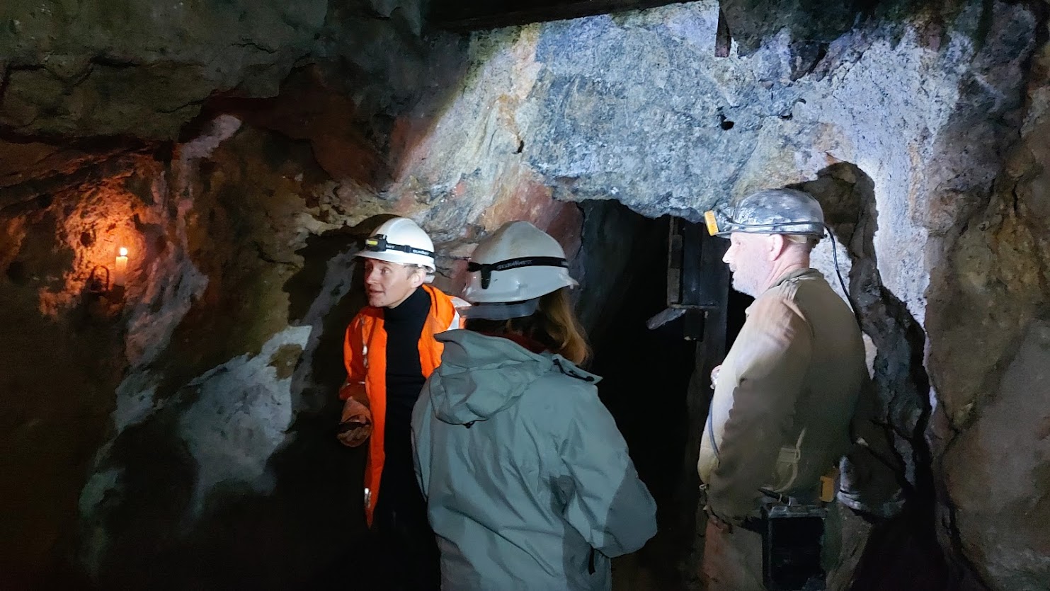
The Rosevale Reconstruction The first hurdle we had was finding a location in Cornwall where we could conduct the experiment. Dolcoath has been decommissioned and flooded with water, as have many of the deep mines within Cornwall. We were in luck when we identified Rosevale mine in Zennor; this was a working mine run by enthusiasts and ex miners and offered us the opportunity of access, albeit not to the depths that Airy would encounter at Dolcoath. A predominantly Victorian mine, access to levels is by ladders and there are wonderful features such as the original tools and candle wax running down the walls. Like all mines, it is the environment, which is prone to change, and 2020 saw our first hurdle as the mine had been shut due to covid restrictions. The pumps had stopped working and the lower levels flooded, making access an impossibility, so we turned our attention instead to the manufacture of the pendulum.
One of the mine’s core team is a clock repairer, maker, and member of the Royal Horological Society. This was key as Kater pendulums were once quite common but are now incredibly rare instruments. We could not take an original into the damp, dirty and dangerous environment of a mine and quickly identified that we would need to build one of our own, which could at worst take damage from transport in and out to its subsurface location. The making of the pendulum would require detailed information about materials, fixings, sizes and processes. We soon discovered that pendulums had been made from a number of different materials, brass, copper, wood and in some cases steel. Our investigations into exact measurements of the pendulums were equally elusive. This led us to the conclusion that we needed to see an original for ourselves. We found that one of these pendulums was housed at the Science Museum in London and after many delays due to covid restrictions one of our team Dr Daniel Belteki had the opportunity to photograph one in the late summer of 2021. This information has allowed Wayne Ridgeway the clockmaker to make a replica pendulum. A last-minute change at the end of December due to one of our team contracting covid saw us delaying the experiment until Spring 2022.
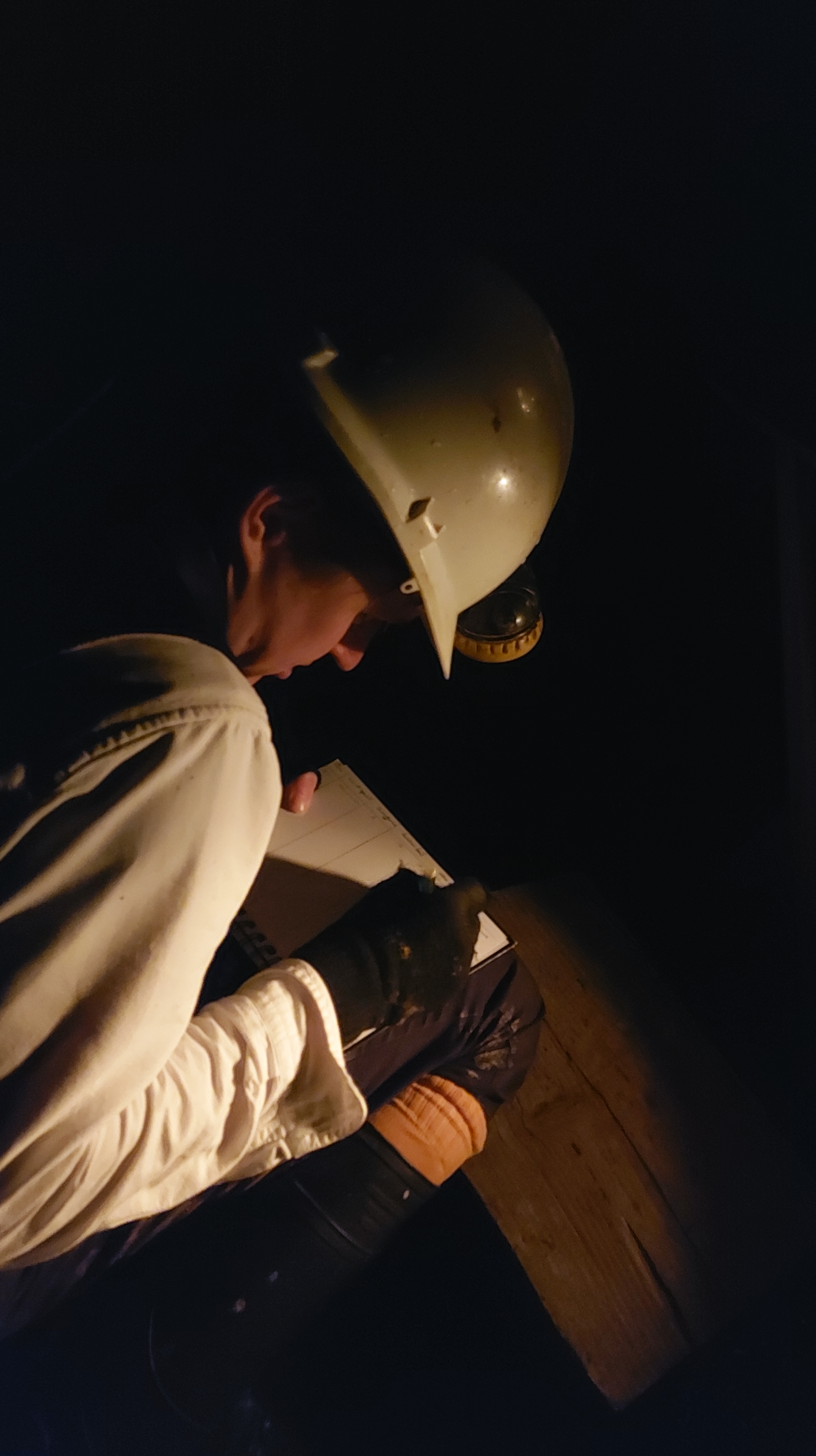
The Experiment On 9 April 2022 we finally got the opportunity to run the experiment. Wayne Ridgeway had completed his manufacture of a Katar Pendulum replica and he had acquired a regulator to be positioned behind. We had chosen a location in the mine which was not too wet or had too much of a draft. The temperature was cool around 11 degrees and we could see your breath in the air. Dr Edward Gillin, Dr Daniel Belteki and I waited patiently as Wayne positioned and started the regulator, before leaving it to settle. He then hung the free-swinging Katar pendulum a short distance in front.
The regulator pendulum had a white dot upon it and the Katar pendulum had a black piece of wood which extended below the bob. It would be these two key elements that we would be watching during the course of the experiment. Positioning ourselves a short distance away we placed a small antique brass sighting scope on a table. Looking through this scope we would be watching for the moment that the white dot was ‘eclipsed’ by the black rod. In effect, it would disappear. This would be the timing that the two pendulums would be swinging together and the original experiments were called coincidences. We could anticipate when these would be forthcoming, as the pendulums visually started to look as though they were swinging in harmony, rather than in opposite directions. A coincidence deep in a mine would occur faster than one at the surface and it is this difference which would allow Airy and Whewell to undertake their calculations.
The first coincidence was witnessed by me. I found myself at the sighting scope just minutes before it was due to occur. It had been a challenge to focus on the pendulum through the small sighting scope, and I had felt a moment of panic when I thought that would be visually usable to undertake the measurement. A realisation that I had to use my peripheral vision, much in the way an astronomer would when teasing out detail on a planetary disc. I allowed my eyesight to settle and soon saw the inverted small image of the white dot and black rod through the sighting scope. As the first person to witness the event, it was very hard to know what to expect what I can claim to have seen is the eclipsing of the white dot, not once but twice, the first time for less than a second and then the second time for a longer period of 16 seconds. My experience was similar but unique to those that followed. Daniel Belteki made the observation of the second coincidence and he didn’t see a complete covering of the white dot, but he did see a maximum covering not once but twice, shortly spaced apart in time, Edward Gillin saw something similar when he had a go at the third coincidence.
Each coincidence was timed between 44 and 46 minutes apart and we felt this had more to do with the expertise of the instrument maker than the observers. With more time and coincidences I am sure we would have made improvements in the accuracy of the observations. It had taken a long time that morning to set up the equipment and get the regulator running smoothly. After nearly 5 hours of observations, we had to allow the mine to pack up and dismantle the experiment. Our limitations were very apparent, we had a lack of time to repeat the experiments to a similar length as Airy and Whewell (they conducted 127 hours in total), and we also lacked depth in which to conduct the experiment. Even so, this has whetted our appetite to try again and improve on our first attempt. We felt we were very successful in exploring the challenges involved in undertaking such an experiment in a less than ideal location and we are all looking forward to a time when we can reconvene and try it all over again. See also: George Biddell Airy, ‘Account of experiments made at Dolcoath Mine, in Cornwall, in 1826, & 1828 for the purpose of determining the density of the earth’, in P. D. Hingley and T. C. Daniel (eds.), A far-off vision: a Cornishman at Greenwich Observatory. ‘Auto-Biographical Notes’ by Edwin Dunkin, F.R.S., F.R.A.S., (1821-1898), with notes on the lives & work of his father, brother and son, (Royal Institution of Cornwall: Truro, 1999). Sedgwick (1890) quoted in, John Willis Clark and Thomas McKenny Hughes, The Life and Letters of the Reverend Adam Sedgwick, LL.D., D.C.L., F.R.S., Fellow of Trinity College, Cambridge, Prebendary of Norwich, Woodwardian Professor of Geology, 1818-1873, Vol. I of II, (Cambridge University Press: Cambridge, 1890), p. 332.
On summer solstice eve I was able to photograph the alignment between the circle and the setting sun over Brown Willy and the setting sun lines up well with the prominent hill. Even taking into account that in prehistory the sun wouldn’t set in exactly the same position today (it would be 2 solar discs to the right in the photo above) there is a clear correlation between the two.
Craddock Moor circle isn’t the only prehistoric site where you can watch the summer solstice sunset over Brown Willy and there is an extended line of monuments across the moor where this can be seen. These include the standing stone above the Hurlers and at Goodaver circle.
Craddock Moor circle has another alignment this time with the rising summer solstice sun and Stowe’s Hill. The winter solstice sunrise and sunset have a loose arrangement with the barrows on Caradon Hill and a rolling sunset down Tregarrick Tor. This makes it a very remarkable solstice-aligned circle.
On solstice eve I was treated to sun dogs forming either side of the sun which was a magical sight which kept me watching the skies before the sunset.
How did we weigh the Earth (and why did this go beyond simple curiosity)? This may be a question people asked themselves during childhood, and have not considered since. Yet it is a question a small group of scientists, including myself, have returned to as we research experiments conducted in the 1820s in a Cornish mine to measure the acceleration due to gravity of the Earth.
In 2022 our intention to re-create the mine experiments by building a replica Kater invariable pendulum and taking it down a Victorian mine in west Cornwall to make measurements of gravity. We will set the pendulum in two locations, one overground and one underground, and time the swing of the pendulum in both locations. The difference in the rate allows us to calculate the amount of gravitational pull on the pendulum, as the underground pendulum will swing at a slower rate. The original experiment was conducted by George Biddell Airy and William Whewell in the deepest mine in England, Dolcoath. This has unfortunately closed and the lower recesses are flooded, so we are using a mine named Rosevale, which gives us a difference of 250 metres between the overground and underground stations. Although Rosevale is not as deep as Dolcoath (700 metres at the time of the original experiment), it gives the opportunity to explore how the experiment was conducted in what can only be described as less than ideal conditions. Mines are dirty places which can be excessively damp and hot. During the original experiment the scientists would have had to contend with vibrations and noise from the working environment, making their achievements all the more significant.
Why is this all important now you may ask? Yes, simple curiosity does play into this but we find ourselves in a time when the power of gravity is something we have learnt to manipulate and overcome. There are frequent launches into space and discussions of journeys to far-flung destinations such as Mars. Without the arduous and at times dangerous early experimentations into measuring the gravity of the Earth untaken by Airy, Whewell and others we could still be stuck without the knowledge to reach beyond our own planet. Therefore we think it is the perfect time to highlight the work they undertook and their achievements in what was an important building block for us to travel into space.
Please be aware that Goodaver Circle is on private land and permission must be sought before visiting it.
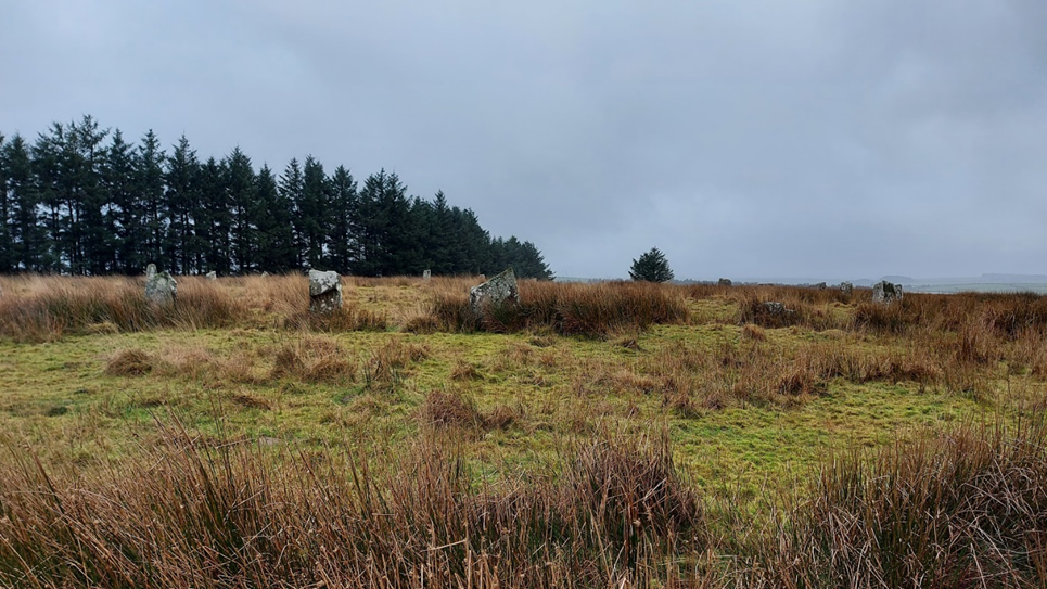
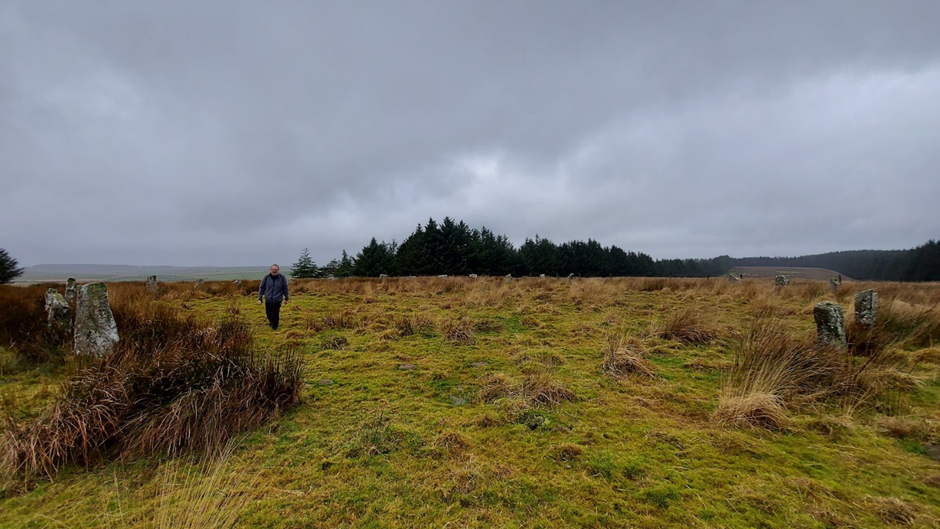
Within the digitised Stanley Opie collection of photographs at Penzance’s Morrab Library, three images bear the title “Unidentified stone circle. Possibly on Bodmin Moor.” These photos initially evoke the essence of a typical Bodmin Moor circle akin to the Stripple Stones, nestled in expansive moorland with panoramic vistas.
Stanley Opie, an archaeologist with a penchant for capturing historic sites and archaeological excavations in Cornwall, was born in Barncoose, Redruth, in 1884. Armed with an Ensign Cameo No. 2 camera and Imperial Eclipse plates, he documented these sites from 1930 to 1950. The Morrab Library in Penzance now houses its comprehensive collection, which has been meticulously digitized and is accessible online and through authorized visits. Throughout his career, Opie photographed numerous locations in Cornwall and beyond, presenting a formidable challenge in identifying the locales depicted in his images.
Closer scrutiny of the three images confirms their association with the Goodaver stone circle on Bodmin Moor. This revelation may surprise observers, as a contemporary visit to the site reveals a markedly different landscape. Presently surrounded by trees from a local plantation, the circle’s original context is obscured. However, this wooded enclosure provides a tantalizing glimpse into the potential positioning of the circle and its conceivable sightlines. Such insights allow us to speculate about astronomical alignments that may have held significance for the circle’s original builders.
In the current era, the entire site is enveloped by trees, except for a western view that descends to the farm and riverbed below. An opportunity arose to capture the site before aligning Opie’s photos with the landscape features, offering a unique perspective on the possible sightlines that the original builders may have considered when siting their circle, unobstructed by the present-day vegetation.
The Rabbit stone helped orientate the circle in the photos (to the left of the image
It helped that there were several unusually shaped stones. One in particular got named the rabbit stone after having a similar profile of the Lindt rabbit, it can be seen on the left of this image. (I should say at this stage that the circle was heavily restored in 1906 and some of the stones are thought to have been replaced incorrectly, even upside down).
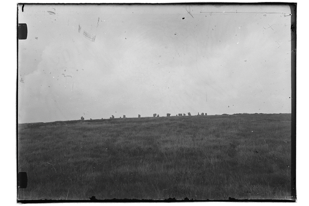
Opie Photograph no 1
This image took a bit of matching. The two central blocky-looking stones and the rabbit-shaped stone on the right of the image helped orientate it. In my image below the rabbit, the stone is also to the right and slightly obscured by the rocks in front of it.
The rise in the ground beyond the circle is Brown Gelly, which is towards the southwest. This Tor is obscured by the trees on the left of the more recent image. The area has several interesting ancient sites on it including some Cairns on the top, which can be seen on the ridgeline of the image. There can be no solar or lunar alignment with these local cairns as they are too far to the south when standing within the circle.
This second image gives a more expansive view looking out from the circle to several ridgeways and hills beyond.
Looking at the stones in the image, the tall pointy stone and gap next to the man at the front of the circle helped orientate the image, as did the rabbit-shaped stone behind him. The image looks from the south of the circle facing north.
The hill towards the centre-left of the image is Leskernick, Bronn Wennili (Brown Willy) may be visible to the left of the image. This is exciting as it means that standing in the circle you could have seen the summer solstice sunset over the distant hill. This is an extension of the line which starts at the newly discovered menhir on the ridge above the Hurlers Circle, extends through Craddock Moor Circle and the avenue at Craddock Moor, and onwards to Goodaver Circle. Making it possible to see the same summer solstice sunset at important prehistoric locations across the moor.
Continuing to the centre-right of the image is the local plantation ridge. Fox Tor which is relatively local to the circle would have been to the right of the image.
The pointed stone that the man is standing beside in the Opie image is front left in the recent one. My image is orientated slightly differently from the old image. It would have been pointing directly down the field to the right of the modern image. Looking down the neighbouring field in recent times there is no possibility of seeing what hills lay beyond.
The Opie photo shows stones in profile against the sky above with no plantation beyond, the rabbit-shaped stone is in the front row of the circle on the central left. Matching it to my photos of the circle, it has been taken from the northwestern side of the circle down the ridge a little way. Kilmar Tor would have been visible if the photo had been taken with slightly increased elevation. This Tor is directly east from the circle and in the position of the rising sun at the equinox (midpoint between the solstices). The modern photo has been taken from higher up the hill and the craggy tops of Kilmar Tor can still be seen through the gaps made by the less dense boundary of trees.
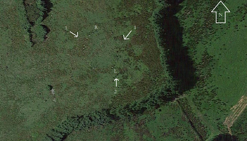
A plan of the matched direction of the photographs taken by Opie numbered 1-3
From matching the photographs old to modern I was able to make a plan of the directions which the Opie images were taken: The plan below is as follows:
R = Rabbit stone
L = taller long stone
Credit: Annotated Google Maps image
Finally, I should add that within the Opie photographs, none were taken in the direction of Hawks Tor in the west. This has been identified by Cheryl Straffon and John Barnett as an equinox setting position when standing in the circle. When visiting the circle in more recent times the Tor can still be seen in the gap made by the plantation to the west and is the one remaining solar alignment that could be viewed in action. Maybe one day the larger plantation trees will be replaced with smaller saplings and make the other viewpoints possible.
Access to the Stanley Opie collection and all the other wonderful historic digitalised images that the library has can be made here:
The importance of the Sun has been recognised throughout history. This luminous body defined the lives of people it shone on and the clocklike regularity of its rise and the set was well understood by humanity. Due to its significance symbolic representation of the Sun stretches far back into prehistory. Designs including the Sun weren’t uncommon and by the Bronze Age examples of solar symbolism are found across a range of mediums. Drawings and designs were often abstract in nature. Representation included circles, waves and cross shapes. The cruciform shape in particular has been linked to the Sun by Mary Cahill (2015) and her work on Irish Sun discs. These are flat circular objects made of gold, designed to shine brightly when sunlight radiates onto them. The etching of a cross on the surface shows the rays of the Sun in a conceptual way, maybe representing various solar events such as; Sundogs, pillars, rays and halos. Although no Sun discs have been found in Cornwall, these golden objects have also been linked to the lunula. A lunula was found with a pair of Sun discs in Coggalbeg, Co Roscommon, confirming an association. Furthermore designs on lunula lend themselves to observation with sunlight. There are examples of lunula found here in Cornwall and if you get the chance it is worth visiting the Penlee House Gallery where the Penwith Lunula is on display.
Sun discs with cross-shaped designs were found at Tedavnet, Co. Monaghan Ireland. Image Credit: The British Museum.
Other objects discovered in Cornwall from this period incorporate a cross design. Although perhaps not as glamorous as a golden disc, local urns can include a similar decoration. Trevisker style urns are a design of urn which are predominantly found in the South West of the UK. Dating from the Bronze Age the style is known for its hash/dash and zig-zag lines and use of local materials such as gabbroic clay from the Lizard peninsular. On occasion, the urns have a cross or cruciform design within the interior of the base. This seems to be a rare occurrence but there have been examples of cross based urns found at the Trevisker village excavation, Boleigh barrow, Tregeseal chambered tomb and an example from further afield in Kent. This final example was placed in a ring ditch, and the soot recovered from inside the Urn was radio carbon-dated to 1600-1320 cal BC. It was found shattered into over 200 pieces but was reconstructed, with its internally crossed base being clearly observable. The urn from the Tregeseal chambered tomb was recovered by William Copeland Borlase in 1879. Found at the end of the passage, in a separate area, it was recovered almost complete by Borlase during his excavation. It now resides within the British Museum. Tregeseal Chambered tomb is part of a group of Bronze Age entrance graves in Penwith which include Bosiliack, Tregiffian and Pennance. As an aside radiocarbon dating results on a burial at Bosiliack gave 1690-1510 cal BC (Jones, A and Thomas, C. 2010) a similar date to the urn found in Kent. The Tregeseal urn is a large example and is 21 inches in height. The Cross shape was meticulously drawn in plan form at the time. The plan was reproduced in the London Illustrated Times and it can also be seen on the wall of the Penlee House Gallery Museum in Penzance.
Trevisker Urn from Tregeseal. Image Credit British Museum Collection Online. The cross itself would not be integral to the structure of the urn. There seems to be no practical explanation as to why an urn of this size would have this addition in the base. It is therefore interesting to consider if some Trevisker urns could be following the tradition of Sun discs and offer a design that is indicative of solar symbolism? One aspect which strengthens the case of this idea is that the Urn would have started as a disc shape on which the cross shape would be added. Then the sides would have been added to the urn creating the final vessel. Looking down from the mouth of the urn it would have clearly taken on representation of the Sun in a similar way to the Sun disc design. An alternative explanation has been offered by Kavanagh, R (1973) who suggested that the cross was added to demonstrate a bottom of a basket and was a nod to the basketry traditions of the period.
The Tregeseal Urn base – in plan. Image credit: Report by W.C Borlase circa 1879
The Tregeseal example was discovered within the tomb base up, containing cremated remains. So the cross would have been above the remains. This could have been intentional. Many funerary urns are found base up. A cross at the top could represent a number of ideas. A Sun in the dark? A route to the heavens? A set Sun? There was just one time of the year which the Sun would shine down the chamber to its rear. This was the winter solstice sunrise. A recent survey undertaken by Carolyn Kennett and Grenville Prowse supervised by Penwith Landscape Partnership archaeologist Jeanette Radcliffe found the passage to be orientated at 128degrees. This orientation towards the solar extreme of winter solstice sunrise is in common with local tombs at Bosiliack and Pennance. On this day the sunlight would shine down the passageway hitting the back upright stone at the rear. The urn was positioned behind this back stone in a separate area or cist. Although currently it is difficult to understand the full design of the tomb, as this rear section has been removed and our understanding is reliant on the original plan from the Borlase excavation. It is also worth considering if the positioning of the urn in a separate section was intentional? This position would ensure that no natural sunlight would reach the urn at any time. The symbolism may have shown that it was providing its own light, even on this important day of renewal in the solar calendar. A photograph taken by Gibson and Sons at the time of the excavation shows a possible blocking stone at the start of the passageway, which would have further limited light down the passage on the solstice. There is no evidence remaining of this stone now, so it is difficult to understand the overall effect this would have had on limiting light at the solstice. It is worth remembering that the final resting place of this urn probably came after a life of servitude. The urn in Kent had traces of animal fats within it and was probably used as a transportation vessel for food before its final role as a funerary urn. Trevisker style urns are not the only vessels to include crosses on their base. Although in general this cruciform addition to urns is rare and seems to be reserved for the more decorative funerary examples. Other examples of cross based urns have been found in Ireland, Scotland and Yorkshire. As a final thought, I doubt we shall ever know the full truth behind this oddity in the design, but it is a nice idea to consider that the cross was added by our ancestors to bring light to the darkest of places.
Cahill, M. (2015) Here comes the Sun – Solar symbolism in Early Bronze Age Ireland. Archaeology Ireland 29(1), 26-33,, 2015.
Jones, A and Thomas, C (2010) Bosiliack and a reconsideration of Entrance Graves. Proceedings of the Prehistoric Society. 76, 2010, pp 271-296.
Kavanagh, R (1973) The Encrusted Urn in Ireland, Proceedings of the Royal Irish Academy: Archaeology, Culture, History, Literature, Vol. 73 (1973), pp. 507-617
First published in Meyn Mamvro 95 (Spring/Summer 2018) and still can be read in the collected works Watching the Sun Booklet by Meyn Mamvro and Mayes Creative (2021)
During the last few years, in many ways, Boscawen-ûn became a second home to me. While waiting for sunrises and sunsets I observed the change in the seasons at the circle, all accompanied by the changing looks, sounds and smells. But one thing remained the same and that was the tranquillity of the site. I kept some strange hours, as I was mainly there for sunrises or sunsets and quite often at night. More often than not I was alone in the circle, sometimes for hours on end. One of these visits, in particular, comes to the forefront of my mind. Having risen when it was still dark, I drove to the circle with the beginnings of dawn, hoping the low developing horizontal cloud would clear. I arrived in time for the sunrise of the 25th June 2016. The week had been wet and the solstice had passed behind a thick blanket of cloud. I stood atop Creeg Tol willing the low bank of clouds to blow out of the way, even though I knew I was nearly a week late to see the summer solstice sunrise. The vantage point of Creeg Tol meant that I would see the Sun peer above the horizon, something that I could not replicate in person in the circle below due to the large hedge obscuring this direction. The dawn had a stillness about it which makes it one of my favourite times of the day. The clouds were starting to disperse and right on schedule, the Sun started to peer above the horizon, accompanied by the mixed dawn chorus of birds, roosters and cattle. I photographed the sunrise from my vantage point at Creeg Tol and set off down the hill towards the circle. About halfway down into the hill I started to lose the sunrise, the Sun was setting behind the hill it had just risen from. By the time I reached the circle the Sun was once again well below the horizon. I realised that without the hedgerow I could witness the Sun rising twice, in effect a double sunrise. Once from atop Creeg Tol and then again from inside the circle. I hoped this would work in reverse: with the Sun setting visually from the circle and once again from Creeg Tol. It was an idea I would test out repeatedly over the summer months with great success. I think this double sunset and sunrise during the summer months is one of the most visually beautiful aspects of the circle. A local settlement Goldherring, which has some Bronze Age round huts is north of the site and people could have accessed the circle from the direction of Creeg Tol. Double sunsets and double sunrises are something that we can all witness from the site and this is only the beginning of what makes Boscawen-ûn astronomically special.
It is important to consider Boscawen-ûn in the landscape as holistically as possible. During this project, I wanted to consider the way the circle sat at the base of the northern hill, in what would have been a marshy area and quite possibly difficult to get access to, particularly at wet times. Why had it been positioned here? What would have been seen in the sky? It was equally important to view the site as a part of a changing landscape, where man has shaped and changed the site itself over a large period of time as well as the surrounding landscape. I am a great believer in looking what archaeoastronomy ideas have been historically suggested about a site. These historic ideas brought another list of questions such as: Is there any truth in a Lunar link at Boscawen-ûn? Does the carving on the back of the central stone light up at summer solstice? These were just the start of a list of burning questions that would keep me returning to the site, making measurements, and calculating positions of celestial objects over the coming year. Hopefully enabling me to answer if the site was built with astronomy in mind.
I started by considering if there were any alignments between the circle and features on the horizon. This meant that I needed to map out all the natural and man-made features which would have been found from the period of the stone circle. This was in itself quite a task. The internet was a wealth of information, but local knowledge from people such as Cheryl was a great help to me. Many local sites such as barrows and menhirs had disappeared and I needed to try to reconstruct where they were as accurate as possible in relation to the circle. My final list identified 48 local features or as I would name them, targets. These targets would then be considered against a number of pre-selected celestial events. If all 48 targets were considered against the chosen celestial events, statistically a match would be highly likely. For instance, if we were to consider the targets located around the site in a circle of 360 degrees. If each target considered covered 1 degree with an error of +/- 0.5 degrees a total of 96 degrees or just over a quarter of our circle would be covered in targets. (The error from this project was set as 1.04 degrees this came from a small amount of measurement error as well as error for refraction, extinction, and parallax). Statistically, this would mean that it would be far more likely for a target to make a match with a considered event. Therefore to make the project more robust I needed to reduce the number of targets. I decided first of all to consider targets that were visible from the site and only targets that sat proud against the horizon. The reduction in targets could have been undertaken in a number of ways but I felt that this made the most robust format for retesting any results. This left me with just 7 remaining targets out of the original 48 to match with my events. These were as follows:
The Lamorna Gap – yes it is just visible from the site through the hedgerows. A smaller sea gap further south to the Lamorna gap, Creeg Tol. A barrow just west of Creeg Tol, Chapel Carn Brea, Boscawen-ûn Field Menhir and finally Bunkers Hill Menhir (East). Once the targets were identified I made on-site measurements of their azimuth and altitude and this was converted into an astronomical declination. Alongside the on-site measurements, I ran a computer program called HORIZON. This also gave me declinations for my 7 targets and it acted as a test of accuracy for the on-site measurement, as well as allowing for reconstruction of the horizon behind the hidden, hedgerow covered NE direction.
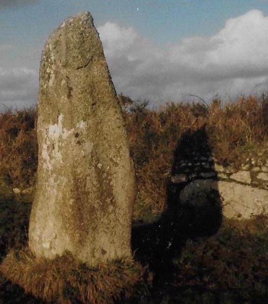
Boscawen-ûn Field Menhir, with possible fallen menhir in hedge behind (Credit Cheryl Straffon)
Next, I considered which astronomical events I would examine alongside the targets. I decided to look initially at five events in total. These five events would give 14 positions along the horizon: 7 rising positions and 7 setting positions. These were the extremes of the solar calendar or the solstices, as well as the solar equinox positions. I also considered the lunar standstill positions both for lunar major and lunar minor. I then calculated the declinations of these 14 events for a date of 2500BCE. The horizon position of a solstice Sun and the lunar positions in 2500BCE has moved slightly compared to its current position, whereas the equinox would be in virtually the same place. So a rising solstice Sun would have a declination of 23.9 degrees in 2500BCE whereas it would have a declination of 23.4 degrees currently which is on a flat horizon at the latitude of Boscawen-ûn equates to an azimuth difference of 1.02 degrees.
When all this was considered I could look for matches between my 14 events and 7 targets. I could see immediately that 4 of my 7 targets declinations matched with one of the fourteen identified events, within the limits of the error I had set. The first and probably most primary of these is that an observer in the circle at 2500BCE would see the winter solstice sunrise rising from the Lamorna Gap. The Lamorna Gap at present is obscured by hedgerows, but without this vegetation would have been a subtle sea view at best. The Lamorna gap declination was measured as -23.6 +/-1.04 degrees, matching a winter solstice sunrise of 23.9 degrees. Also, you must consider that the sea view extends for more than 1 degree along the horizon and that this event could be observable over the coming millennia.
Winter Solstice sunrise
This first alignment extends through the circle to my second alignment. This is to a barrow which is no longer visible, it was located to the west of Creeg Tol. It would be in the position of the summer solstice sunset when observed from the circle. It had a measured declination of 24.3 +/- 1.04 degrees coinciding with the declination of 24.9 degrees. Equally an observer at the barrow would have been in a position to observe the winter solstice sunrise out of the Lamorna Gap. Its position just above the circle would give an observer a more advantageous height and a more pronounced view of the winter solstice sunrise from the Lamorna Gap. It is interesting to note that the winter solstice sunset at this time would just fall into the large sea gap at the Tregeseal stone circles. Although at Tregeseal the sea gap is far more pronounced, there is possible that there is a connection between the two sites on this date.
The other two matched alignments came between the circle and lunar major standstill positions. I found that the position of Creeg Tol matched the lunar major sunset northernmost position, it had a measured declination of 28.3+/-1.04 degrees coinciding with an event declination of 28.9 degrees. The nearby Boscawen-ûn Field menhir was the final alignment and it was in the lunar major sunrise position. This had a measured declination of 28.9+/1.04-degrees which coincided with the event declination of 28.15 degrees in 2500BCE. The position of the Field menhir was slightly to the west of calculated declination for the lunar alignment, but it is conceivable that another stone now recumbent in the hedge made a pair and this pair once framed the rising Moon at the extreme of the lunar major cycle. Although we should note here that it may not have necessarily been a full Moon at that time, as the Moon at its standstill declination can be at a number of positions within in its phase cycle.
Lunar standstill links are not well documented in Cornwall. They are considered a feature of recumbent stone circles in East Scotland but have also been found in western Ireland and more recently in western Scotland. The discovery of two lunar standstill points at Boscawen-ûn is both interesting and intriguing; raising more questions than it answers. Boscawen-ûn does have myths surrounding it which are linked to the lunar cycle, so this could be a feature of this site. Future work in west Penwith will consider evidence for lunar links. For instance, the Merry Maidens which I had discounted through my reduction of data, as it did not stand proud against the horizon is in the Lunar Major Standstill Southern rising position from Boscawen-ûn with a declination of 29.9 degrees. This concludes the main horizon findings but as I said I also looked at other features within the circle.
Boscawen-ûn hedge menhir (Credit Carolyn Kennett)
The positioning of the quartz stone to the SW of the circle could signify the start or end of the winter season, but due to its localised vicinity to an observer, it could never pinpoint an actual date, without another position to line it up. The stone on the opposite side could have well been used to align the position but this does not line up with anything calendrically significant. The quartz stone does though align with the cist (located in the NE of the circle) and the out of sight Boscawen-ûn Hedge menhir. The summer solstice sunrise would have occurred along this alignment around 2500BCE. This alignment was first suggested by Norman Lockyer in his consideration of the circle. There is another stone between the Hedge menhir and the stone circle, this would possibly bring inter-visibility between the circle and the Boscawen-ûn Hedge menhir. Even so, there are numerous examples of standing stones being just over brows of ridges that form alignments so this could be a viable consideration when looking at this alignment.
The edge of the foot at the bottom of the central stone is illuminated (Credit Carolyn Kennett)
Rock art carving (or either foot or axes) have been identified on the central stone. I was able to calculate the amount of time the art would be illuminated for in the year 2500BCE. The art on the back of the central stone is only fully illuminated in and around summer solstice sunrise. Without any vegetation, a full illumination would occur for 30 days on either side of the solstice. The maximum time in minutes that the art would be illuminated would occur on the summer solstice. This amount of time would reduce each day until a full illumination could not happen 31 days later. It must be noted that this measurement takes into account a completely flat landscape. Any vegetation would significantly reduce the length of time and amount of days the art would be fully illuminated. Partial illumination of the art also occurs and this time it happens both in the morning and the evening in and around the summer solstice, this partial illumination would occur over a much longer period.
There are many more suggestions that could be made particularly linking stellar events to the site. Without more accurate dating these suggestions must be taken under advisement. For instance, the Pleiades would set over Chapel Carn Brea in 1500BCE but at an earlier date of 1800BCE, it would have set to the south of the framed hill. I did consider if the central stone could have pointed at a star. The only bright star that it could have pointed at was Arcturus and this would have been at a remarkably early date of 3820BCE. This must be taken under advisement, as the stone could have moved over time. Overall the suggestions of stellar alignments without accurate dating are always difficult to suggest. It does seem that a number of astronomical features were considered by the builders of Boscawen-ûn. They certainly had an eye for the solar calendar within the design but perhaps more unusually a knowledge of the lunar cycle. This project, for me, has raised more questions than it answered and I will be continuing it by looking for further examples of lunar alignments within Cornwall and trying to draw more conclusions about the astronomical features at some of the other Cornish circle sites.
More of this story can be read about in my book Celestial Stone Circles of West Cornwall. Which can be accessed here