
Please be aware that Goodaver Circle is on private land and permission must be sought before visiting it.
Within the digitised Stanley Opie collection of photographs at Penzance’s Morrab Library, three images bear the title “Unidentified stone circle. Possibly on Bodmin Moor.” These photos initially evoke the essence of a typical Bodmin Moor circle akin to the Stripple Stones, nestled in expansive moorland with panoramic vistas.
Stanley Opie, an archaeologist with a penchant for capturing historic sites and archaeological excavations in Cornwall, was born in Barncoose, Redruth, in 1884. Armed with an Ensign Cameo No. 2 camera and Imperial Eclipse plates, he documented these sites from 1930 to 1950. The Morrab Library in Penzance now houses its comprehensive collection, which has been meticulously digitized and is accessible online and through authorized visits. Throughout his career, Opie photographed numerous locations in Cornwall and beyond, presenting a formidable challenge in identifying the locales depicted in his images.
Closer scrutiny of the three images confirms their association with the Goodaver stone circle on Bodmin Moor. This revelation may surprise observers, as a contemporary visit to the site reveals a markedly different landscape. Presently surrounded by trees from a local plantation, the circle’s original context is obscured. However, this wooded enclosure provides a tantalizing glimpse into the potential positioning of the circle and its conceivable sightlines. Such insights allow us to speculate about astronomical alignments that may have held significance for the circle’s original builders.
In the current era, the entire site is enveloped by trees, except for a western view that descends to the farm and riverbed below. An opportunity arose to capture the site before aligning Opie’s photos with the landscape features, offering a unique perspective on the possible sightlines that the original builders may have considered when siting their circle, unobstructed by the present-day vegetation.

The Rabbit stone helped orientate the circle in the photos (to the left of the image
It helped that there were several unusually shaped stones. One in particular got named the rabbit stone after having a similar profile of the Lindt rabbit, it can be seen on the left of this image. (I should say at this stage that the circle was heavily restored in 1906 and some of the stones are thought to have been replaced incorrectly, even upside down).
Opie Photograph no 1
This image took a bit of matching. The two central blocky-looking stones and the rabbit-shaped stone on the right of the image helped orientate it. In my image below the rabbit, the stone is also to the right and slightly obscured by the rocks in front of it.
The rise in the ground beyond the circle is Brown Gelly, which is towards the southwest. This Tor is obscured by the trees on the left of the more recent image. The area has several interesting ancient sites on it including some Cairns on the top, which can be seen on the ridgeline of the image. There can be no solar or lunar alignment with these local cairns as they are too far to the south when standing within the circle.

Stanley Opie, “Unidentified stone circle. Possibly on Bodmin Moor,” Morrab Library Photographic Archive, accessed January 4, 2022, http://photoarchive.morrablibrary.org.uk/items/show/6371
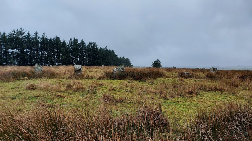
Image 1 match
Opie Photograph number 2
This second image gives a more expansive view looking out from the circle to several ridgeways and hills beyond.
Looking at the stones in the image, the tall pointy stone and gap next to the man at the front of the circle helped orientate the image, as did the rabbit-shaped stone behind him. The image looks from the south of the circle facing north.
The hill towards the centre-left of the image is Leskernick, Bronn Wennili (Brown Willy) may be visible to the left of the image. This is exciting as it means that standing in the circle you could have seen the summer solstice sunset over the distant hill. This is an extension of the line which starts at the newly discovered menhir on the ridge above the Hurlers Circle, extends through Craddock Moor Circle and the avenue at Craddock Moor, and onwards to Goodaver Circle. Making it possible to see the same summer solstice sunset at important prehistoric locations across the moor.
Continuing to the centre-right of the image is the local plantation ridge. Fox Tor which is relatively local to the circle would have been to the right of the image.
The pointed stone that the man is standing beside in the Opie image is front left in the recent one. My image is orientated slightly differently from the old image. It would have been pointing directly down the field to the right of the modern image. Looking down the neighbouring field in recent times there is no possibility of seeing what hills lay beyond.

Stanley Opie, “Unidentified stone circle. Possibly on Bodmin Moor,” Morrab Library Photographic Archive, accessed January 4, 2022, http://photoarchive.morrablibrary.org.uk/items/show/6370
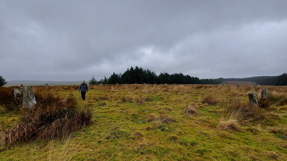
Image 2 Match
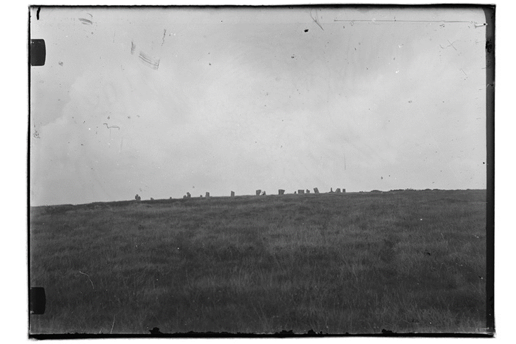
Opie Photograph no 3
The Opie photo shows stones in profile against the sky above with no plantation beyond, the rabbit-shaped stone is in the front row of the circle on the central left. Matching it to my photos of the circle, it has been taken from the northwestern side of the circle down the ridge a little way. Kilmar Tor would have been visible if the photo had been taken with slightly increased elevation. This Tor is directly east from the circle and in the position of the rising sun at the equinox (midpoint between the solstices). The modern photo has been taken from higher up the hill and the craggy tops of Kilmar Tor can still be seen through the gaps made by the less dense boundary of trees.
Stanley Opie, “Unidentified stone circle. Possibly on Bodmin Moor,” Morrab Library Photographic Archive, accessed January 4, 2022, http://photoarchive.morrablibrary.org.uk/items/show/6372

Image 3 Match
A plan of the matched direction of the photographs taken by Opie numbered 1-3
From matching the photographs old to modern I was able to make a plan of the directions which the Opie images were taken: The plan below is as follows:
R = Rabbit stone
L = taller long stone
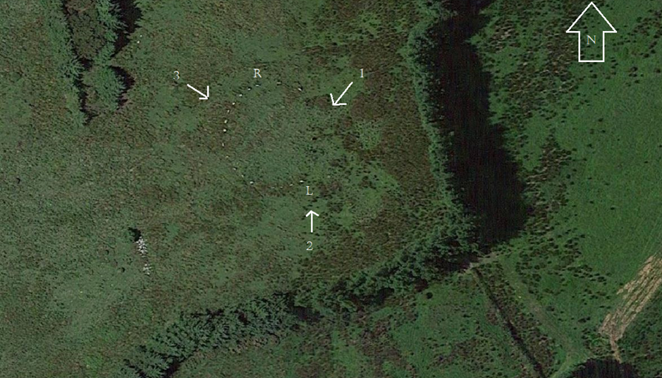
Credit: Annotated Google Maps image
Finally, I should add that within the Opie photographs, none were taken in the direction of Hawks Tor in the west. This has been identified by Cheryl Straffon and John Barnett as an equinox setting position when standing in the circle. When visiting the circle in more recent times the Tor can still be seen in the gap made by the plantation to the west and is the one remaining solar alignment that could be viewed in action. Maybe one day the larger plantation trees will be replaced with smaller saplings and make the other viewpoints possible.
Access to the Stanley Opie collection and all the other wonderful historic digitalised images that the library has can be made here:
